|
Arctic and Antarctica
Reference:
Suleymanov A.A.
The History of Geocryological Study of the Coastal-Shelf Zone of the Laptev and East Siberian Seas in the 1950s–1980s
// Arctic and Antarctica.
2023. ą 1.
P. 14-25.
DOI: 10.7256/2453-8922.2023.1.39874 EDN: PIKAKG URL: https://en.nbpublish.com/library_read_article.php?id=39874
The History of Geocryological Study of the Coastal-Shelf Zone of the Laptev and East Siberian Seas in the 1950s–1980s
Suleymanov Aleksandr Albertovich
ORCID: 0000-0001-8746-258X
PhD in History
Senior Researcher, Institute for Humanities Research and Indigenous Studies of the North of Siberian branch of the Russian Academy of Sciences
677027, Russia, Republic of Sakha (Yakutia), Yakutsk, Petrovsky str., 1, room 403

|
alexas1306@gmail.com
|
|
 |
Other publications by this author
|
|
|
DOI: 10.7256/2453-8922.2023.1.39874
EDN: PIKAKG
Received:
01-03-2023
Published:
22-04-2023
Abstract:
The historical analysis of the studies carried out during the 1950s-1980s by the staff of the Yakutsk Permafrost Research Station of the Obruchev Permafrost Institute of the USSR Academy of Sciences and since 1962 – organized on its basis by the Permafrost Institute of the Siberian Branch of the USSR Academy of Sciences and aimed at studying the coastal-shelf zone of the Laptev Sea and the East Siberian Sea. The sources for the preparation of the article were the archival materials identified by the author from the funds of the Russian State Archive of Economics and the Archive of the Melnikov Permafrost Institute of SB RAS, as well as scientific literature data. The work carried out made it possible to show the significant activity of researchers in the study of subbottom permafrost. Its drivers were both purely cognitive interest and the needs of the industrial development of high latitudes. In the course of the surveys carried out, data were obtained characterizing the prevalence and thickness of subpermafrost, its temperature regime, composition and other properties.
Keywords:
Arctic, Yakutia, Laptev Sea, East Siberian Sea, shelf of the Arctic seas, history of science, scientific research, the USSR Academy of Sciences, geocryology, subbottom permafrost
This article is automatically translated.
IntroductionThe Arctic zone of the Republic of Sakha (Yakutia) (hereinafter referred to as Yakutia) includes 13 administrative districts (uluses), the total area of which exceeds 1600 thousand square kilometers. Almost completely this huge territory is located north of the Arctic Circle and is located in the zone of continuous permafrost ("permafrost"), which have a decisive influence on the characteristics of conducting economic activities in the region, including exploration and extraction of minerals. At the same time, the richest reserves of gold, diamonds, tin, and rare earth metals are stored in the depths of the Arctic regions of Yakutia, and there are significant prospects in terms of oil and gas potential [11]. From the north, Arctic Yakutia is washed by the waters of the seas of the Arctic Ocean – the Laptev Sea and the East Siberian Sea. The importance of understanding the presence and limits of the prevalence of permafrost rocks here, their thickness and temperature regime increased with increasing interest in the economic potential of the Arctic seas shelf in our country. The comprehension and historical analysis of the accumulated experience in this regard, especially in the light of current plans for the reindustrialization of the Russian Arctic as one of the responses to sanctions pressure, seems to be an important task today. It also actualizes the problem under consideration and the state of its scientific elaboration. Currently, the historiography of the topic is represented only by a number of works that are devoted to the formation of geocryological science and its development in Yakutia [1; 2; 14], several biographical studies, which mention the organization and participation of individual scientists in research conducted, including in the coastal shelf zone [12; 16; 17], as well as M.N. Grigoriev's doctoral dissertation "Cryomorphogenesis and lithodynamics of the coastal shelf zone of the seas of Eastern Siberia" [13], which provides a brief historical overview of the research carried out on this topic. The authors of all these works thus set themselves completely different tasks. In this regard, the purpose of this article is to reconstruct the history of the most representative geocryological studies conducted in the coastal shelf zone of the Laptev Sea and the East Siberian Sea in the period from the first surveys of this orientation to the end of the Soviet era, the transformations that followed led to significant changes, including in the field of scientific research in the Russian Arctic. At the same time, taking into account the limited scope of the article, the author's attention will focus only on studies in which employees of the leading actor of the geocryological study of the Arctic regions of Yakutia participated in the period under review: initially the Yakut Permafrost Research Station of the V.A. Obruchev Institute of Permafrost Studies of the USSR Academy of Sciences (YANIMS INMERO), and since 1962 – organized based on it, the Institute of Permafrost Studies of the Siberian Branch of the Academy of Sciences (IMZ SB AS) of the USSR (Yakutsk). Materials and methodsThe work is based mainly on the analysis of expedition and scientific reports that were identified by the author during the search work in the Russian State Archive of Economics (Moscow) and the Archive of the Institute of Permafrost named after P.I. Melnikov of the Siberian Branch of the Russian Academy of Sciences (IMZ SB RAS, Yakutsk), as well as accumulated scientific literature, in more or less relevant to the problem under consideration. Results and discussionProbably, the first geocryological studies in Yakutia, within the framework of which, among other things, permafrost rocks in the coastal shelf zone were studied, were the works of the participants of the Northern Detachment of YANIMS INMERO, Ph.D. N.F. Grigoriev (beginning) and drilling foreman K.A. Stroev in 1951. Surveys were carried out in the estuaries of Yana and Indigirka at the request of the Yakut Aerogeodetic Enterprise to increase the efficiency of the process of ground work on aerial photography in the Arctic regions of Yakutia, which had significant specificity due to the shallow occurrence of permafrost rocks here. The research was combined with work in the coastal shelf zone. In the period from August 18 to August 28, N.F. Grigoriev, K.A. Stroev and two hired workers began surveys on the Right Channel located at the mouth of the river. Yany island of Niriai-Ary on the coast of the Laptev Sea. Route surveys were conducted on this island in order to study its geomorphology and geology, and a well with a depth of 13 m was drilled to measure the temperature of permafrost rocks. In addition, geocryologists drilled two wells at the bottom of the Laptev Sea at a distance of 10 km from the shore. At a sea depth of 1.5 – 1.7 m, the wells were deepened into the bottom by 2 – 3.5 m [19, l. 1-7]. The information obtained during the drilling of wells allowed us to establish the depth of the upper boundary of the "permafrost" and its approximate capacity on the seabed at the site of the survey. In addition to purely cognitive value, these materials had a certain value in finding solutions to the problem of deepening the fairway in the area of the Yana estuary bar [20, l. 1-20]. 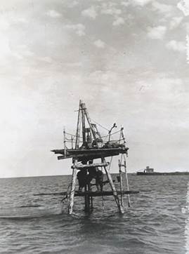
Fig. 1. Drilling of a well by the participants of the Northern detachment of YANIMS INMERO in 1951. Photo by N.F. Grigoriev [3, L. 14]. The research of permafrost was continued in April 1953, when during the work of Expedition No. 1 INMERO in Polar Yakutia, its participants, again under the leadership of N.F. Grigoriev, laid 15 sounding wells with a depth of 1 to 6 m along the mainland coast from the ice of Dmitry Laptev Strait [21, l. 11-12].
Research of this kind became more focused in the 60s of the twentieth century. During 1962-1963, the Northern Expedition of the IMZ SB of the USSR Academy of Sciences (N.F. Grigoriev) was conducted in the Arctic regions of Yakutia. One of the independent tasks of the expedition was to "determine the conditions of heat exchange and thermal regime of permafrost rocks in the shelf zone and coastal parts of the Arctic seas" [4, L. 9]. The task of the Primorsky detachment, headed by N.F. Grigoriev himself, was to conduct research on the coast of the East Siberian Sea in the area of the bar (sandy underwater shoal at the mouth) of the Indigirka River, Sandy Island in the Laptev Sea, in the area of Tiksi Bay, as well as in the Kara Sea on Vilkitsky Island. Along with the leader, 11 other researchers were part of the team in 1962. The floating base for geocryologists was the Polar lighter, which was towed by the RBT-48 boat. Movements to the immediate place of work were carried out by boat or boat [4, l. 11-16]. On July 15, the researchers arrived on the "Polar" from Chokurdakh at the mouth of the Middle Channel and began work that lasted for a month along the seashore of the Indigirka Delta near Nemkov Island. In the Indigirka Delta, the first reference well was drilled on the sands of Primorye periodically flooded by the sea. In total, geocryologists have laid 8 wells in this area with a depth of 3 to 9.6 m. Of these, 3 wells were located within sandbanks. The remaining 5 were drilled using a collapsible drilling tripod in the sea. Drilling in this case was carried out from a platform, the height of which was adjusted depending on the depth of the sea. After the end of drilling, electrothermometers were lowered into the well, with the help of which the temperature of bottom sediments was measured at one-and-a-half meter intervals. N.F. Grigoriev, thus, used and improved the experience he gained during the previously named surveys of 1951 and 1953. In the process of permafrost-geological survey, along with drilling wells, to determine the structure, composition and temperature of permafrost rocks, a number of pits with a depth of up to 1.5 m were passed. In addition, during the survey, water temperature measurements were carried out at different horizons, as well as with the help of a probe – the depth of seasonal thawing of bottom sediments, geomorphological observations were made [4, L. 17-42]. The following year, the participants of the Primorsky detachment, already under the leadership of M.S. Ivanov, continued their research in the coastal shelf zone. In April – May 1963, geocryologists carried out surveys in the area of the Yana River bar. Here, researchers from the sea ice drilled 6 wells up to 10 m deep and laid 3 sounding pits. As a result of the research, the temperature of bottom sediments was determined at different depths, including on the sea slope of the bar, and in some areas to a depth of 2 m below the seabed. After that, the participants of the Primorsky detachment went to the fishing village of Yuedei, located in the northeastern part of the Yana Delta. The floating base of the detachment was a rented motor ship "Lisa Chaikina". In the vicinity of Yuedei, researchers drilled 6 wells, including a reference one, which had a depth of 20 m. A cycle of temperature observations was carried out in all wells, and the extracted cores were described and transferred for laboratory studies. Two more wells were drilled from aboard the Lisa Chaikina at the bottom of the Yansky seashore using tripods. Upon completion of the work, some of the participants of the Primorsky detachment with drilling equipment and equipment were transferred by AN-2 aircraft from Nizhneyansk to the village of Yukagir. 3 more wells were drilled here on the eastern shore of the Siellakh Bay. At the same time, one of them was passed at the bottom of the sea at a distance of 700 m from the shore to a depth of 6 m. During its drilling, cores of frozen marine bottom and coastal sediments were selected and described. Temperature measurements were carried out at different depths in all three wells [5, l. 7-13]. The surveys carried out within the framework of the Northern Expedition of the IMZ SB of the USSR Academy of Sciences made it possible to obtain a set of information that related to the geothermal features of the coastal strip and shallow areas of the sea, cryogenic textures of delta and marine sediments. Based on this information, scientists identified the types of deposits and presented the characteristics of the formation of each of them. On this basis, the history of the development of permafrost rocks on the shores, shoals and bottom of the coastal part of the sea was reconstructed [4, l. 17-76]. 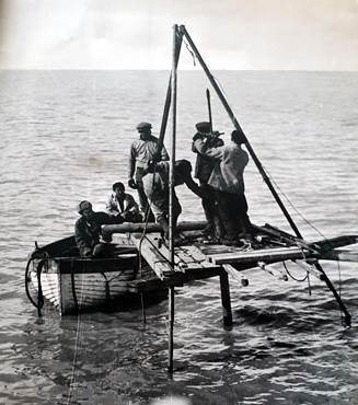
Fig. 2. Drilling of a well by the participants of the Northern Expedition of 1962-1963. The East Siberian Sea in the delta area of the Indigirki, 1962 Photo by N.F. Grigoriev [4, l. 12] The work of the participants of the Northern Expedition actually marked the beginning of a comprehensive study of the conditions for the formation and distribution of permafrost rocks at the bottom of the continental shelf, shallow bays and estuarine seas of the Arctic basin. As a result of the conducted surveys, the first classification of types of frozen strata was developed, it was found that in the vast majority of the water area of the shelf under consideration at depths exceeding the thickness of the ice cover, permafrost rocks have a relict origin. At the same time, geocryologists proved the possibility of the formation of permafrost deposits in modern conditions in shallow areas of the waters of the seas washing the shores of Yakutia [22, p. 60-67].
A new impetus to research on the Arctic shelf in the Soviet Union was given by the creation in 1972 on the basis of the Research Institute of Arctic Geology (Leningrad), as well as Polar (Lomonosov), Marine Arctic (Murmansk) and Norilsk expeditions of the Northern Marine Scientific and Production Geological and Geophysical Association (Sevmorgeo). The reasons for its appearance were, firstly, the successes of a number of Western countries in the development of oil and gas resources of the shelf of the northern seas, and secondly, the emergence of serious grounds for starting the search for similar deposits on the Arctic shelf of the Soviet Union. In particular, in 1969 In the Ministry of Geology of the USSR, the country's first "Map of the prospects of oil and gas potential of the Arctic coast and shelf of the USSR" was presented on a scale of 1:5000000 with an estimate of forecast resources of 60 billion tons. In this context, it is not surprising that the priority task assigned to Sevmorgeo, whose head was appointed the future academician of the USSR Academy of Sciences, Doctor of I.S. Gramberg, began work related to the study of the oil and gas potential of the Arctic shelf of the Soviet Union, which included a complex of geological and geophysical surveys [15]. A member of one of these expeditions, carried out in the coastal zone of the islands of Bolshoy Lyakhovsky and Bunge Land, as well as in the waters of the Sannikov Strait, was a senior laboratory assistant of the IMZ SB of the USSR Academy of Sciences A.I. Fartyshev. The purpose of the researcher's research in 1974-1975 was to study the history of the formation, composition and cryogenic structure of quaternary sediments, the parameters of the subaqual cryolithozone in the Sannikov Strait and to clarify the features of the development of re-vein ice in the area. To achieve it, A.I. Fartyshev studied the core from more than 70 drilled wells up to 140 m deep. Temperature measurements were carried out in 10 of these wells, and the composition, structure and iciness of rocks were studied in 40 of these wells. In addition, the geocryologist studied sections of 16 natural outcrops and 30 pits, determined the humidity of 60 samples of frozen rocks, and also selected more than 300 samples for chemical, spore-pollen and diatom analyses, determining their absolute age in laboratory conditions [6, L. 4]. As a result of the generalization of the data obtained, A.I. Fartyshev revealed the structural features of Cenozoic deposits of cryogenic origin, established the temperature of permafrost rocks on the islands of Bolshoy Lyakhovsky and Bunge Land, as well as the permafrost-geological situation in the Sannikov Strait. In addition, on the basis of geomorphological, permafrost-facies and chemical analyses, the researcher traced the genesis of the formation of alasoid basins located in the coastal zone. Analysis of the rocks extracted from the bottom of the Sannikov Strait allowed A.I. Fartyshev to conclude that there are several historical cycles of deep freezing and thawing of marine rocks. At the same time, the thickness of these rocks with a thickness of 50-60 m has a negative temperature and includes permafrost soils [6, l. 29-108]. With the need for scientific support for the development of natural resources of the Arctic shelf of the Soviet Union, F.E. Are, E.N. Molochushkin, V.V. Voichenko and Z.N. Antipina (IMZ SB of the USSR Academy of Sciences) linked the preparation of a "Forecast map of the cryolithozone distribution under the bottom of the Arctic seas and the Polar Basin." It should be noted that the work on the map has largely become possible thanks to the array of data accumulated during the studies discussed above. In addition, the temperature indicators of the bottom layers of water on the shelf were used, identified during long-term surveys by employees of the Arctic and Antarctic Research Institute (AANI) [7, L. 5-7]. As the map compilers noted, geological exploration on the shelf, construction of offshore structures, development of subaqual mineral deposits required the same consideration of a complex of cryogenic factors, "as in the development of natural resources of the land." At the same time, at that time, the "geocryological study of the seabed" was at an "extremely low level" [7, L. 4]. In this regard, it is significant that when drawing up the map, the researchers relied primarily on the generalization of available data on the origin, temperature and salinity of the bottom layers of the Arctic basin and its marginal seas. Based on this work by Z.N. Antipina, calculations and mathematical modeling of the degradation of permafrost rocks under the seabed were carried out on the M-222 computer [7, l. 9-45]. The conducted surveys allowed F.E. Are, E.N. Molochushkin, V.V. Voichenko and Z.N. Antipina in 1976 to make a forecast map of the distribution of the subaqual cryolithozone in the Asian sector of the Arctic – under the bottom of the Kara and Chukchi Seas, the Laptev Sea and the East Siberian Sea on a scale of 1:10000000 [7, l. 51]. Soon the further study of "permafrost" on the shelf areas of the Arctic seas was developed. In the field season of 1978, employees of the IMZ SB of the USSR Academy of Sciences A.V. Efimov, A.I. Fartyshev, V.Y. Shamshurin, Yu.F. Uritsky, V.V. Polubelov, I.I. Baranov, A.E. Kuzmin were engaged in research in the waters of the East Siberian Sea near the island of Bolshoy Lyakhovsky. The surveys were carried out in accordance with a tripartite agreement concluded by IMZ with the USSR Academy of Sciences, Sevmorgeo and AANI. It should be noted that Sevmorgeo's interest in working in the area was due to the fact that it carried out exploratory drilling within the shelf zone for tin [8, l. 6-8]. In the period from May 20 to July 26, the research covered the water area of the East Siberian Sea adjacent to the northern tip of Bolshoy Lyakhovsky Island. The work here included the sinking by Sevmorgeo specialists of 8 wells up to 62 m deep. 7 of these wells were drilled from the ice of the East Siberian Sea at a distance of 1.1 km to 160 m from the shore. Another one is on the shore in close proximity to the sea. During the survey, geocryologists carried out 23 measurements of soil temperature at various depths in these wells, monitored the restoration of the natural temperature regime of rocks, and also selected their samples for subsequent laboratory analysis. As a result of the research, scientists determined the composition, humidity, salinity, specific gravity, thermophysical properties of the rocks composing the shelf cryolithozone, compiled its typologization and established a capacity of 50-70 m or more [8, l. 9-116].
In the early 80s of the twentieth century, geocryological research in Polar Yakutia received a significant impetus as part of the implementation of the fundamental program "Siberia" [18]. During 1981-1985, the Northern (Arctic) Expedition of the IMZ SB of the USSR Academy of Sciences was conducted in the Lena Delta. The scientific leadership of the expedition was initially carried out by the Doctor of Scientific Sciences F.E. Are, then Academician of the USSR Academy of Sciences P.I. Melnikov. The heads of the expedition were Ph.D. M.I. Tishin (1981), V.V. Kunitsky (1982-1983), S.Y. Korolev (1984) and M.N. Grigoriev (1985) - the son of N.F. Grigoriev. The main focus of the research of the participants of the Arctic Expedition of the IMZ SB of the USSR Academy of Sciences was to study the genesis of frozen quaternary sediments in the coastal zone of the Laptev Sea, to clarify the patterns of their development and accumulation conditions. The total area of the research area was about 36 square kilometers and covered the territory from the Chekanovsky ridge in the west to the Kharaulakh Mountains in the east and the coastal zone of the Laptev Sea between Buor-Khaya and Olenek Bay in the north. The expedition work was carried out in spring and summer. In total, over the course of 5 years, the expedition participants overcame about 550 km of land and water routes (the expedition vessel Cryosphere, the Progress-2M boat and smaller watercraft), during which sections of frozen quaternary sediments in outcrops on the Bykovsky Peninsula, Muostakh Islands, Arga-Muora-Sis and others in Olenekskaya were studied, Malaya Tumatskaya, Trofimovskaya and Bykovskaya channels of the Lena River. In addition, aerial visual observations and drilling of more than 60 wells were carried out. The expedition participants were based at the Razdelny stronghold near the Bykovsky Peninsula [9, l. 7-12; 10, l. 5-11]. 38 of the wells in the spring were drilled from the surface of the Laptev Sea ice cover. Some of them had a depth of more than 50 m and were located at a distance of 1-3 km from the shore. The core samples obtained during drilling were documented. In addition, a layer-by-layer determination of humidity and selection of frozen rocks for their subsequent laboratory study were carried out. During the cameral period, granulometric analysis of the obtained material, analysis of the chemical composition of soil samples and marine extracts, underground ice, and radiocarbon dating of the absolute age of rocks were carried out in laboratory conditions. Several core samples delivered to the laboratory in an undisturbed frozen state were examined to determine thermal conductivity and heat capacity. 
Fig. 3. Drilling sledge-tractor train of participants of the Northern (Arctic) expedition of the IMZ SB of the USSR Academy of Sciences [9, l. 478] The surveys carried out in the coastal strip of the Laptev Sea made it possible for the first time to prove the widespread distribution of sub-frozen rocks at a distance of up to 3 km from the coastline. An important result was the compilation of a schematic cryoliotological map of the studied area on a scale of 1:1000000, which the staff of the Institute of Geology of the Yakut branch of the SB Academy of Sciences of the USSR O.V. Grinenko and A.I. Sergeenko called "the actual scheme of forecasting the possibilities of using the territory for various national economic purposes" [10, L. 260-261]. At the same time, it should be noted that the survey participants were forced to abandon their initial plans for a detailed study of the formation and development of permafrost rocks in the coastal shelf zone due to insufficient technical equipment of the expedition [10, l. 8] - even during the period that is often called "golden" in the history of Russian science, researchers have not always had a resource opportunity to carry out all their plans. Despite this, the Arctic Expedition of the IMZ SB of the USSR Academy of Sciences became one of the largest in the Soviet history of geocryological knowledge of the coastal shelf zone of the seas surrounding Yakutia, its participants performed a very significant set of works aimed at studying frozen strata, using a wide range of methods for studying the cryolithozone, the skills of which were accumulated by that time in the walls Institute of Permafrost Studies of the SB Academy of Sciences of the USSR. ConclusionThe presented material indicates that geocryological surveys in the coastal shelf zone of the Laptev Sea and the East Siberian Sea developed quite actively during the considered period. The intensity of research in this direction was determined both by purely cognitive interest, the desire to obtain new information within the framework of a relatively young science at that time – geocryology, and purely practical. In the 1950s, apparently, it was more important to optimize the process of work on the transport development of the Arctic zone of Yakutia, taking into account the need for vessels of various classes to enter the estuaries of the northern rivers. With the receipt of information about the prospects of mining on the shelf of minerals, understanding the accumulated world experience in this regard, the most important driver of research work was the natural resource potential of the coastal shelf zone, which was most clearly manifested since the early 70s of the twentieth century. It should also be noted the rhythmic improvement of geocryologists' research methods, their technical equipment and the introduction of new approaches to the analysis of the data obtained, including the use of computers. In particular, this allowed geocryologists in the course of the surveys considered to obtain data not only on the issues of the prevalence and capacity of permafrost that initially interested them, but also on its temperature regime, composition and various properties.
References
1. Academic geocryology in Yakutia / Ed. ed. R.M. Kamensky. Yakutsk: PI SB RAS, 1997. 328 p.
2. Academic science in Yakutia (1949–2009) / Ch. ed. A.F. Safronov, responsible ed. V.V. Shepelev. Novosibirsk: Geo, 2009. 220 p.
3. Arhiv of Mel'nikov Permafrost Intitute of the Siberian branch of the Russian Academy of Sciences (PI SB RAS). D. 332. 20 l.
4. Arhiv PI SB RAS. D. 720. 540 l.
5. Arhiv PI SB RAS. D. 829. 371 l.
6. Arhiv PI SB RAS. D. 1368. 108 l.
7. Arhiv PI SB RAS. D. 1402. 54 l.
8. Arhiv PI SB RAS. D. 1482. 151 l.
9. Arhiv PI SB RAS. D. 1623. 420 l.
10. Arhiv PI SB RAS. D. 1657. 261 l.
11. Volkov A.V. Mining industry of Arctic Yakutia // Portal on the development of the Arctic. Access mode: https://goarctic.ru/politics/gornodobyvayushchaya-promyshlennost-arkticheskoy-yakutii/ (date of access: 10.02.2023)
12. Grigoriev M.N. Grigoriev Nikolay Filippovich. Series "Permafrost scientists". Yakutsk: PI SB RAS, 2000. 63 p.
13. Grigoriev M.N. Cryomorphogenesis and lithodynamics of the coastal-shelf zone of the seas of Eastern Siberia: dis. ... Dr. geogr. Sciences. Yakutsk: PI SB RAS, 2008. 291 p.
14. Obruchev Permafrost Institute: 1939—1963 / Ed. V.P. Melnikov, V.V. Baulin. Novosibirsk: Geo, 2007. 193 p.
15. Kaminsky V.D., Ivanov V.L. The role of NIIGA-VNIIOkeangeologiya in polar and marine geological science // 70 years in the Arctic, Antarctic and the World Ocean. Collection of scientific papers. St. Petersburg: VNIIOkeangeologiya, 2018, pp. 3–18.
16. Klimovsky I.V. Academician Pavel Ivanovich Melnikov. Novosibirsk: Geo, 2008. 305 p.
17. Klimovsky I.V., Mandarov A.A. Are Felix Ernestovich (on the occasion of his 75th birthday // Cryosphere of the Earth. 2002. No. 3, pp. 100–101.
18. Kupershtokh N.A. Development and implementation of socio-economic projects of the comprehensive program "Siberia" in the 1980-1990s. // Historical and economic research. 2018. No. 4, pp. 514-528. DOI 10.17150/2308-2588.2018.19(4).514-528.
19. Russian State Archive of Economics (RSAE). F. 82. Op. 2. D. 605. 21 l.
20. RSAE. F. 82. Op. 2. D. 633. 20 l.
21. RSAE. F. 82. Op. 2. D. 716. 27 l.
22. Suleymanov A.A. Research of the Northern Expedition of the Institute of Permafrost Science of the Siberian Branch of the USSR Academy of Sciences in 1962–1963. in the Arctic regions of Yakutia // North-Eastern humanitarian bulletin. 2021. No. 3, pp. 57–67. DOI 10.25693/SVGV.2021.36.3.006.
Peer Review
Peer reviewers' evaluations remain confidential and are not disclosed to the public. Only external reviews, authorized for publication by the article's author(s), are made public. Typically, these final reviews are conducted after the manuscript's revision. Adhering to our double-blind review policy, the reviewer's identity is kept confidential.
The list of publisher reviewers can be found here.
REVIEW of the article "From the history of the geocryological study of the coastal shelf zone of the Laptev and East Siberian seas in the 1950s-1980s." The subject of the study is the history of the geocryological study of the coastal shelf zone of the Laptev and East Siberian seas in the 1950s-1980s. The chronological scope of the study is limited to the 1950s and 1980s, i.e. the Soviet period, when serious attention was paid to the study of the Arctic zone of the country, including the Laptev Seas region, etc. both from a scientific and economic point of view. The research methodology is based on general scientific methods and special historical ones (comparative historical and system-comparative, etc.). The relevance of the study is due to the economic role of the region "in the light of current plans for the reindustrialization of the Russian Arctic as one of the responses to the sanctions pressure of foreign countries." In addition, there is a request for a scientific study of this economically important zone. In this regard, the historiographical study of the topic is of great interest. From a historiographical point of view, there are only a few works that are devoted to the issues of "the formation of geocryological science and its development in Yakutia" and several "biographical studies", which address the issues of organization and participation of individual scientists who conducted research in the coastal shelf zone and several more works, which in one way or another are given a brief overview of historical research. The scientific novelty of the reviewed work lies in the fact that it aims to "reconstruct the history of the most representative geocryological studies conducted in the coastal shelf zone of the Laptev Sea and the East Siberian Sea in the period from the first surveys of a similar orientation to the end of the Soviet era." In fact, this is the first work in which the analysis of research will be carried out by the staff of the Yakut Scientific Research Permafrost Station of the Institute of Permafrost named after V.A. Obruchev of the USSR Academy of Sciences (YANIMS INMERO), and since 1962 - the Institute of Permafrost Studies of the Siberian Branch of the Academy of Sciences (IMZ SB AS) of the USSR (Yakutsk) organized on its basis. In fact, this organization is the leading one in the field of geocryological study of the Arctic regions of Yakutia in the chronological period considered by the authors of the reviewed article. The style of the article is academic and clear. According to the reviewer, the sources were used competently in the article, the methods of scientific knowledge were used competently, and the principles of logic, systematics and consistency of presentation of the material were observed. The structure of the work is logically structured and consists of the following blocks: introduction, materials and methods, results and discussion, conclusion. The structure of the work is aimed at achieving the purpose of the work and the tasks set. The bibliography of the reviewed article consists of 22 sources (these are articles and other works on the topic, archival materials ) and in general, it indicates knowledge of the subject of the study and also indicates that the author has raised a serious and to date poorly researched topic. The appeal to the opponents is stated on the example of an analysis of the literature on the topic mentioned in the article. In addition, the work done by the author and the conclusions give an answer to the opponents. Conclusions, the interest of the readership. The author's conclusions follow from the serious work done by the author on all available sources (materials from the Russian State Archive of Economics and the Archive of the P.I. Melnikov Institute of Permafrost Studies of the Siberian Branch of the Russian Academy of Sciences), some of these materials are introduced into scientific circulation for the first time and the works of their predecessors. The work will be of interest to both specialists and a wide range of readers, given its relevance.
|


