|
Security Issues
Reference:
Shevchuk, D.V., Ermakov, S.V. (2025). Goal setting for the development of an adaptive system for assessing the current and predicted values of the vessel's squat. Security Issues, 4, 1–14. https://doi.org/10.25136/2409-7543.2025.4.75846
Goal setting for the development of an adaptive system for assessing the current and predicted values of the vessel's squat
Shevchuk Danila Vladimirovich
ORCID: 0009-0003-7861-5005
Postgraduate student; Department of Navigation and Maritime Safety; Kaliningrad State Technical University
6 Molodezhnaya str., Kaliningrad, Kaliningrad region, 236035, Russia

|
schevchuk.dan@yandex.ru
|
|
 |
|
Ermakov Sergey Vladimirovich
ORCID: 0009-0009-7814-8877
PhD in Technical Science
Associate Professor; Department of Navigation and Maritime Safety; Kaliningrad State Technical University
6 Molodezhnaya str., Kaliningrad, Kaliningrad region, 236035, Russia
|
|
esv.klgd@mail.ru
|
|
 |
Other publications by this author
|
|
|
DOI: 10.25136/2409-7543.2025.4.75846
EDN:
YHYUVH
Received:
09/10/2025
Published:
09/22/2025
Abstract: The relevance of the study is due to the need to create a universal reliable valid accurate method for determining the vessel's squat, since all existing methods, techniques, algorithms, formulas are limited in use and do not fully possess all the specified characteristics. The object of the study is the navigational safety. The subject of the study is the vessel's squat in shallow water. The purpose of the study is to form a list of problems to be solved for the effective implementation of the concept of an adaptive system for assessing the current and predicted values of the vessel's squat, and a brief description of the content of these problems. The methodological basis of the study is experiment and measurement, although the work directly presents not the research results obtained by these methods, but the formulation of problems to be solved using them. When substantiating the concept of an adaptive system, such scientific research methods as analysis, synthesis, induction and deduction were used. The novelty of the study lies in the substantiation of the concept of an adaptive system, the hardware of which, among other things, includes such a technical means as a three-antenna satellite compass. The study revealed that the current methodology for determining squat does not contain absolutely reliable and universal methods. At the same time, the system proposed at the conceptual level is also limited in its development due to the lack of a clear understanding of the further direction of the study and the associated set of problems to be solved. In order to eliminate this gap, a list of primary tasks for the evolution and development of an adaptive system for assessing the current and predicted values of the vessel's squat has been formulated, some of which involve conducting full-scale experiments.
Keywords:
economic security, ecological security, navigational safety, squat, UKC, computation, forecasting, system, neural network, architecture
This article is automatically translated.
Introduction The vast majority of cargo is currently transported by sea [1-5]. It is not for nothing that the sea routes are called the blue arteries of the global economy. At the same time, cargoes differ in the same variety as the global gross product, i.e. sea vessels transport almost all types of goods produced in the world. In such circumstances, it is difficult to overestimate the importance of the shipping industry. The world ocean is not only a "road" for ships, but also a habitat for various species of aquatic organisms, most of which belong to fishing facilities. Fishing vessels that produce thousands of tons of fish per day make a huge contribution to ensuring food security (despite the fact that it is not singled out separately by the National Security Strategy of the Russian Federation). Fish products save the population of developing countries from hunger and are a significant part of the diet of residents of developed countries. Thus, transport and fishing vessels are essentially a tool for ensuring economic security [6] — one of the strategic national priorities provided for by the National Security Strategy of the Russian Federation [7, 8]. It is obvious that the reliability, integrity and safety of these instruments determines, among other things, economic security. In other words, the safety of navigation, and in particular the navigational safety of ships, is an integral part of economic security. The emphasis above was placed on navigation safety due to the fact that navigation accidents are the most common threat to navigation safety [9], and therefore a threat to economic security. One of the types of navigation accidents is shipwrecks. In such an accident, environmental safety rather than economic safety may come to the fore [10]. The world practice of shipping knows cases when a stranding and the subsequent leakage of petroleum products into the marine environment led to a drastic change (deterioration) in the way of life of residents of coastal areas, enormous damage, prolonged decline and significant reorientation of the region's economy [11]. In turn, one of the reasons for running a ship aground is ignoring or incorrectly accounting for the so—called high—speed subsidence of the vessel - an increase in its draft when moving in shallow water, as well as a decrease in the water reserve under the keel (UKC - Under Keel Clearance) [12]. The methodology for determining the rate of subsidence is extremely diverse, however, it is not possible to recognize one or another method as unambiguously valid and reliable. There are at least four proofs of this thesis. First, none of the methods is common to several types of vessels. Secondly, many formulas are designed to determine the rate of subsidence of either only the bow or only the stern. Third, there is always a methodological error in any of the formulas for determining the rate of subsidence. And the last, fourth proof is that all methods are based on multiple observations, i.e. they are strictly empirical in nature [13]. At the same time, the development of mathematical tools such as neural networks [14] opens up new ways to develop a methodology for determining the high-speed subsidence of ships. Thus, in [13], the concept of an adaptive system for estimating the current and predictive values of the ship's subsidence velocity was proposed, based precisely on neural networks. At the same time, the basic technical means of this system is a satellite compass, which determines the novelty of the study, since this device has never been used before to determine the rate of subsidence. However, as the etymology and content of the term "concept" implies, this system is presented in [13] exclusively at the level of an idea, with only a small detail of further development. Thus, the next task for the development of a system for assessing the current and predictive values of the ship's subsidence velocity is the task of goal setting, i.e. the task of setting goals and planning actions to achieve them. The present work is devoted to the formation and structuring of a list of primary tasks, including setting and conducting an experiment. As a result, the object of the study is the navigational safety of the vessel's navigation, the subject of the study is the high—speed subsidence of the vessel in shallow water, and the purpose of the study is formulated as follows: to form a list of tasks to be solved for the effective implementation of the concept of an adaptive assessment system for the current and predictive values of the high-speed subsidence of the vessel, and a brief description of the content of these tasks. The essence of high-speed subsidence in the context of the influence of shallow water on ship movement High—speed subsidence is a phenomenon observed when a vessel is moving in shallow water. With this movement, an area of increased pressure is located near the bow of the vessel, in the middle part the pressure drops and rises again towards the stern, having, however, a lower value than in the bow (Fig. 1).
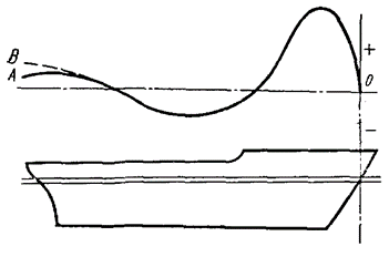
Fig. 1. Pressure distribution around the ship's hull
The solid line in Fig. 1 shows the pressure when the screw is running, which sucks in water, increasing its speed. This leads to a decrease in pressure at the stern of the vessel. In accordance with the described pressure distribution, waves are formed: a crest at the bow, a sole at the midsection, and a second crest of lower height at the stern. Due to the formation of a bow wave of considerable height, the vessel increases the stern trim compared to the state of rest. Divergent waves coming from both the stem and the stern are superimposed on this system of main waves. The essence of the influence of shallow water on the conditions of movement of the vessel is to change the system of waves formed around the hull, which leads to an increase in water resistance, subsidence of the hull, an increase in trim at the stern and a deterioration in controllability.
With Froude numbers less than 0.3-0.4, wave formation is not much different from that in deep water. As the depth decreases at a constant speed of the vessel, or, equivalently, as the speed of the vessel increases at the same depth, the Froude number begins to increase. As it approaches the value of 0.7-0.8, the angle of solution of the diverging waves increases and transverse waves form at the bow and stern of the vessel. The hull of the vessel, located between these two waves, is sagging. The water supply under the keel is decreasing. These changes are accompanied by an increase in wave resistance and friction resistance (due to a decrease in the distance between the bottom of the vessel and the ground). With a further increase in the Froude number and its approach to unity, the formation of a powerful bow wave begins, which the vessel pushes in front of it, located on its rear slope. The stern wave of a much lower height moves aft. This moment corresponds to the greatest water resistance to the movement of the vessel and a sharp increase in trim at the stern. Thus, a change in wave formation during the movement of a vessel in shallow water causes an overall increase in the depth of the vessel, depending on the speed of the vessel, i.e. a rapid subsidence [15].
The concept of an adaptive assessment system current and predictive values of the vessel's rate of subsidence To create a system for determining the rate of subsidence, first of all, it is necessary to justify (select) a method for automatically determining the draft of a vessel under way. In the presented concept, a technique based on the use of a satellite compass, and a three-antenna satellite compass, is adopted as such [16-18]. The advantage of both the technique itself and the indicated course indicator is the ability to determine not only the height of the antenna above sea level, but also the trim, and therefore the draft of the vessel bow and stern, as well as their changes. The system for estimating the current and predictive values of the vessel's rate of subsidence includes (Fig. 2): - Three-antenna satellite compass; - electronic cartographic navigation Information System (ECDIS); - echo sounder is a device for measuring the depth under the keel of a vessel; - the main block is a block for receiving, storing, processing, interpreting and providing information. The main block necessarily contains information about the z coordinate of the satellite compass antenna, as well as the length of the vessel.

Fig. 2. The composition of the adaptive assessment system for the current and predictive values of the ship's rate of subsidence and the calculation scheme for the rate of subsidence
The system should have the following operation algorithm: 1) a satellite compass with a given discreteness measures the height of the antenna and the trim of the vessel, which makes it possible to obtain precipitation, and the main unit records the measured values in its memory; 2) in the case when two measurements standing side by side in time, taking into account smoothing and tolerance, turn out to be equal (there is no rate subsidence), the main unit of the system switches to standby mode.; 3) in the case when the height, trim, or both characteristics simultaneously begin to change from measurement to measurement (precipitation increases, which means that there is a rapid subsidence), the main unit records information slots in its memory after each measurement, and each slot includes: vessel speed (satellite compass), depth (echo sounder), draft changes bow, stern and amidships - direct high—speed subsidence, width of narrowness (ECDIS or radar); 4) each information slot gets to the input of the trained neural network and initiates the next learning cycle; the output of the neural network is the values of the velocity subsidence along the midsection, bow and stern at the available speed.
The presented adaptive system for estimating the current and predictive values of the ship's subsidence velocity and the scheme for calculating the subsidence velocity can function both in real time and in the precalculation (forecasting) mode. In the case of the first mode, the system display tool will provide the user with the value of the velocity subsidence and/or UKC for several (usually three — bow, stern, amidships) points along the length of the vessel and the "depth of the beginning of shallow water". The forecasting mode can be implemented using an additional information layer of the electronic navigation map. To obtain the necessary forecast information about the rate of subsidence and/or depth reserve under the keel, it is enough for the user to hover the cursor over the point of interest in the water area and set the speed of the vessel at which the movement is planned. It should be noted that the use of a trained neural network both in general, in the system itself, and, in particular, in the forecasting mode makes it possible to calculate the rate of subsidence as well as the depth reserve under the keel, in the case when it has not previously sailed in the assessed or similar areas.
List of tasks for the development of an adaptive assessment system current and predictive values of the vessel's rate of subsidence In order to gradually transform the concept of the system into a full-fledged effective tool for continuous automatic determination of the rate of subsidence (depth reserve under the keel), the following list of tasks is proposed. Task 1. Reducing the height of the satellite compass antenna to zero depths. The depth zero [19, 20] is a conditional surface from which the depths shown on the nautical charts are measured. In the Russian Federation, in seas without tides, the average sea level is assumed to be zero depths, and in tidal seas, the lowest sea level is assumed to ensure the safety of navigation. On the Atlantic coast of the USA, the average level of shallow waters is assumed to be zero depths, on the Pacific coast — the average level of low shallow waters, and in most European countries — the average level of syzygy shallow waters. In some ports located in shallow areas and in river mouths with significant surge fluctuations, conditional depth zeros are used, which is specifically indicated in the locations and on the maps. To bring the antenna to zero depths, it is necessary to conduct an experiment in ship conditions, the essence of which is to repeatedly measure the draft along the frame in the plane of which the antenna is located, while simultaneously calculating the height of the tide. Based on the results of each pair of measurements, the values of the correction to zero depths are determined, after processing which the final correction value is obtained. If the antenna height is unknown (not specified anywhere), it can be determined by calculating the vertical distance from the antenna to a point (object) on a ship with a known applicator. Task 2. Conducting experiments on a ship to determine the rate of subsidence (depth reserve under the keel) in various navigation conditions using technical means included in the adaptive assessment system for the current and predictive values of the rate of subsidence of the vessel. To carry out a set of experiments, it is necessary to have information about the coordinates (abscissa, ordinate and application) in the ship's coordinate system of the satellite navigation receiver antenna. If these coordinates are not documented anywhere, they should be measured using reference points with already known coordinates. It is advisable to select such a number of reference points so that the measurement results in a figure of errors. The essence of the first experiment, conducted in the port after preliminary determination of precipitation in the traditional way, is to simultaneously fix the coordinates displayed by the satellite navigation receiver, the height of the antenna, the depth measured by the echo sounder, as well as the magnitude of the tide. The optimal measurement discreteness is 1-2 hours, with mandatory measurements before and after loading and unloading. A similar experiment is carried out at the transition, with the recommended frequency of measurements once an hour (3-4 times per shift). As part of the third task, it is necessary: 1) connect the average sea level and zero depths (as a rule, the smallest water is zero depths, and the average sea level corresponds to the average tide value), 2) compare the average sea level and the level surface (surface of the geoid), 3) to substantiate the methodology for determining the vertical distance between the geoid (mean sea level) and the general terrestrial ellipsoid (in particular, WGS 84) at a specific point (i.e., the methodology for determining the vertical error of the general terrestrial ellipsoid). Task 4. To summarize and analyze the theory and methodology of determining UKC and rate subsidence. Task 5. To substantiate the requirements for a neural network, its architecture, and to evaluate the possibility of using existing and available neural networks for the purposes of this study.
General description of neural networks in the context of adaptive system development estimates of the current and predictive values of the vessel's rate of subsidence
In recent years, artificial neural networks have become widespread in various fields, as they are able to learn from examples and solve complex problems similar to those solved by humans. The main advantage of neural networks is the ability to learn and generalize. A properly trained network reveals hidden dependencies between input and output data and is able to produce the correct result even on new, previously unknown or incomplete data [21]. This makes neural networks a promising tool for automation and decision-making in complex situations that require consideration of many factors, including in assessing the rate of subsidence. Currently, there are many types of neural networks that differ in connection structure and scope. The most well-known and widespread types of neural networks include [21]: - A perceptron is the simplest model of a neural network consisting of inputs, one neuron (or a small number of neurons) and an output, and is capable of solving basic pattern recognition tasks, but its capabilities are not sufficient to solve complex problems.; A fully connected network (multilayer perceptron, MLP) is a simple universal classical direct propagation network used in classification and forecasting tasks and consisting of several layers of neurons, with each of the neurons connected to all the neurons of the next layer, and information flows from the input layer through hidden layers to the output; - convolutional neural network (CNN) is a specialized architecture for image and signal processing used in computer vision tasks and containing convolutional layers that highlight local features: small filters (cores) scan the input image and react to primitive elements (contours, textures, etc.); recurrent neural network (RNN) is an architecture for sequential data (time series, texts, signals), which is used in tasks where order is important (machine translation, speech recognition) and in which neurons have feedback loops that allow them to preserve the internal state and "memory" of previous inputs (when processing a new element The network takes into account the context of the previous elements); - deep neural networks (DNN) — networks with a large (more than 10) number of hidden layers (dozens or more) that can study very complex and abstract patterns due to hierarchical multilevel information processing, require huge amounts of data and computing resources for their training and are the basis of most of humanity's achievements in the field of machine learning (speech recognition systems, self-driving cars). The practical application of neural networks in solving specific problems (including the problem of determining the rate of subsidence) is possible only if the following conditions are met: - reliable data and sample quality — the neural network must be trained on a representative dataset containing all the typical situations it will encounter. sufficient computing power; - correct architecture and configuration — the network structure (number of layers, neurons, types of connections) must match the nature of the task, and the learning parameters must be configured in such a way as to achieve convergence; - testing and validation — after training, the neural network must be thoroughly tested in various scenarios, it is necessary to validate the network on independent data simulating real-world operating conditions (various types of vessels, weather conditions, waves, etc.); - taking into account physical factors and limitations, including through the use of classical formulas and (or) hybrid neuro-fuzzy systems in the input parameters of the network, taking into account a priori expert rules; - security and fault tolerance provided through the integration into neural networks of mechanisms for monitoring decisions made by the neural network, an algorithm for explaining output data (decisions) and the possibility of an emergency transition to manual control or a backup model. Thus, a neural network designed to solve the problem of ensuring the navigational safety of a vessel's navigation (in particular, determining the speed of subsidence) must be well trained on sufficient data, properly configured, tested in all possible conditions and take into account specific factors of maritime practice. The amount of high-speed subsidence of a vessel depends on many factors: speed, hull shape (completeness coefficient), depth-to-draft ratio, water resistance, etc. In order to assess the rate of subsidence and the depth reserve under the keel, the neural network is able to learn from the accumulated results of measurements of the draft of the vessel and identify nonlinear dependencies between the parameters of the vessel, its movement and the magnitude of the rate of subsidence, and, as a result, predict the latter with high accuracy. In fact, the neural network is an electronic consultant: it continuously calculates the current and forecast value of the velocity subsidence and UKC (taking into account speed and conditions) and warns if the stock under the keel is reduced to a dangerous limit. The architecture of the neural network to be used in the adaptive assessment system for the current and predictive values of the ship's subsidence velocity may consist of the following components: - the input unit (sensors and data) through which the system receives data from the ship's navigation instruments and external sources, including: the current depth under the keel (echo sounder), as well as the forecast of the depths ahead along the course (electronic map data), the speed of the vessel and the mode of movement, the static draft of the vessel, loading parameters, roll, trim, hydrological data, wave parameters, size and shape of the vessel;
- a neural network for predicting drawdown — a multilayer neural network (for example, a fully connected neural network, or a neural network with specialization — a combination of convolutional layers for spatial data and recurrent ones for temporal dynamics), accepts parameters from the input block (a set of numerical features) and evaluates the current and predictive values of the rate of subsidence; - the UKC calculation and recommendations module, which in addition performs alarm functions — when the depth reserve under the keel becomes less than required, it generates a warning; - operator interface. The neural network can be trained on a sample containing both the results of model tests and the actual results of determining the rate of subsidence for different vessels and conditions. During the training process, the network learns the correspondence between the input factors (speed, depth, etc.) and the output drawdown value. To improve generalizing abilities, as it was already noted earlier, it is useful to include the results of calculations using known formulas in the training sample. Thus, the neural network will take into account both empirical data and classical dependencies. The presented hypothetical architecture combines a data model (neural network) and a knowledge model (built-in calculations of UKC and thresholds based on rules). The neural network performs the most difficult part — estimating the nonlinear drawdown. As a result, the system is able to help the skipper choose a safe speed in shallow water in real time. It should be noted that to increase reliability, you can use a combination of several networks, or combine a neural network with a Kalman filter that filters out sensor noise. In the simplified architecture presented, these details are omitted, but they can be successfully used in a real project.
Conclusion. In the conditions of modern navigation, the issue of traffic safety in waters with limited depths is of particular importance. A significant proportion of marine accidents and incidents are associated with an incorrect assessment of the rate of subsidence and insufficient depth reserve under the keel. Even a short-term decrease in UKC below critical values can lead to damage to the hull, loss of controllability, landing on the ground, accidental spills of petroleum products and, as a result, to threats to both economic and environmental safety. In this regard, the creation of systems capable of predicting the dynamics of a ship's draft in real time becomes not just a matter of professional comfort, but a necessary condition for the safe operation of the fleet [22]. This paper presents the concept of an adaptive system for estimating the current and predictive values of the ship's subsidence velocity and a scheme for calculating the subsidence velocity, as well as a list of tasks (most of them related to experiments) to be solved for the effective implementation of the concept. It is proposed to use a neural network as a mathematical and simultaneous software tool of the system, since it is artificial neural networks that open up new possibilities for solving problems of ensuring the navigational safety of a vessel (in particular, the tasks of anticipating the rate of subsidence and depth reserve under the keel). Neural networks are capable of predicting the behavior of a vessel in difficult conditions based on large amounts of accumulated data, including current and early assessment of the rate of subsidence and UKC. The main advantage of neural networks in navigation is to remain operational in situations where classical theoretical models cannot produce results or the reliability of the result is questionable. In the case of shallow water, the neural network can serve as an additional electronic assistant that constantly analyzes the situation under the keel and warns of a dangerous approach to the ground. However, the justification, implementation and use of neural networks to determine the rate of subsidence and depth reserve under the keel categorically require an extremely thoughtful approach. Here it is necessary to ensure high-quality training data, ensure that physical limitations are taken into account, and thoroughly test the system before operation. A neural network should complement, not replace, a person: the final decisions are left to the skipper, especially in non-standard situations. Thus, the implementation of the proposed concept through the solution of the tasks outlined in the work and the use of neural networks will make it possible to somewhat offset threats to economic and environmental security.
The article is published in its final version as approved following the last positive peer review recommending acceptance for publication. It incorporates revisions made by the author in response to prior negative peer review reports that did not recommend publication. All peer review reports, including initial negative reviews, are published in open access alongside the article. All versions of the author’s revisions are archived in the publisher’s repository and may be made available upon reasonable request in accordance with Elsevier’s editorial policies and applicable data availability requirements.
Read all reviews on this article
References
1. Seleznev, P. S., & Korenkov, I. O. (2025). The significance of international maritime transport routes for the development of the economy and strengthening national security of Russia. ETAP: Economic Theory, Analysis, Practice, 1, 78-109. https://doi.org/10.24412/2071-6435-2025-1-78-109
2. Akhramieva, A. V. (2025). Retrospective analysis of the evolution of port functions and logistics delivery routes in urban conditions. System Analysis and Logistics, 2, 68-79. https://doi.org/10.31799/2077-5687-2025-2-68-79
3. Koval, V. N. (2024). Features of the application of international private law norms in maritime transport. Moscow Journal of International Law, 2, 33-45. https://doi.org/10.24833/0869–0049-2024-2-33-45
4. Larionova, A. R., & Sviridonova, A. A. (2023). Maritime transport in world trade: Features of organization. In Logistics-Eurasian Bridge: Proceedings of the XVIII International Scientific and Practical Conference (pp. 134-139).
5. Timchenko, T. N., & Aslanov, G. G. (2023). Conceptual approach to organizing maritime transport in ports with limited depths. Exploitation of Maritime Transport, 3, 49-57. https://doi.org/10.34046/aumsuomt108/8
6. Abdurashidova, Kh. B. (2025). Ensuring economic security of countries in the context of global risks. My Professional Career, 2(68), 303-311.
7. Lobanov, V. V. (2025). A modern view on the formation of national security in Russia. Financial Markets and Banks, 2, 125-131.
8. Sagiryan, I. G., & Petrenko, A. S. (2025). The evolution of the concept of "national security" in three editions of the national security strategy of the Russian Federation. Legal Order and Legal Values, 3(1), 34-45. https://doi.org/10.23947/2949-1843-2025-3-1-34-45
9. Abanin, S. S. (2024). The impact of the use of navigation technologies of domestic shipbuilding on safety. Transport Affairs of Russia, 6, 94-97.
10. Lukyanov, G. E., & Maximov, A. A. (2025). Emergency situations at sea: Causes, prevention, and response. Journal of Technical Research, 11(1), 84-88.
11. Bondarev, V. A., & Ermakov, S. V. (2017). Navigation accident in the context of emergency risk management. Problems of Risk Analysis, 14(4), 58-66.
12. Ermakov, S. V. (2017). Study of vessel speed mode on an open straight section of the Kaliningrad Sea Canal. Bulletin of Admiral S. O. Makarov State University of Maritime and Inland Shipping, 9(2), 252-259. https://doi.org/10.21821/2309-5180-2017-9-2-252-259
13. Ermakov, S. V., & Shevchuk, D. V. (2023). Concept of adaptive assessment system for current and predictive values of vessel speed sinking. In Baltic Marine Forum: Proceedings of the XI International Baltic Marine Forum (Vol. 8, pp. 25-28).
14. Zairova, D. K. (2025). Neural network algorithms: Theoretical foundations and mechanisms of operation. Scientific Leader, 3, 39-47.
15. Management of the Ship and Its Technical Operation. E. I. Zhukov, M. N. Libenzon, M. N. Pis'mennyi [et al.]; edited by A. I. Shchetinin. (1983). Transport.
16. Saranchа, A. M. (2019). External radio navigation devices. Modern Science, 12-1, 609-613.
17. Saranchа, A. M. (2017). The satellite compass "Farvater"-an alternative to gyro and magnetic compasses. Aspiring Scientist, 9, 18-21.
18. Komarovsky, Y. A. (2017). Sensitivity of the satellite compass JLR-20. In Problems of Transport in the Far East: Reports of the Scientific and Practical Conference (Vol. 1, pp. 203-221).
19. Reshetnyak, S. V., & Shalnov, L. G. (2020). Practical implementation of the agreed "Zero depth of the Baltic Sea BSCD2000" in the Baltic region countries. Navigation and Hydrography, 59, 37-51.
20. Yelagin, A. A., & Demidov, A. L. (2016). Analysis of methods for determining sea level fluctuations during hydrographic works. Bulletin of Admiral S. O. Makarov State University of Maritime and Inland Shipping, 2, 78-89. https://doi.org/10.21821/2309-5180-2016-8-2-78-89
21. Sergeev, A. P., & Tarasov, D. A. (2017). Introduction to neural network modeling. Edited by A. P. Sergeev. Ural University Press.
22. Maljković, M., Pavić, I., Meštrović, T., & Perković, M. (2024). Ship maneuvering in shallow and narrow waters: Predictive methods and model development review. Journal of Marine Science and Engineering, 12(8), Article 1450.
First Peer Review
Peer reviewers' evaluations remain confidential and are not disclosed to the public. Only external reviews, authorized for publication by the article's author(s), are made public. Typically, these final reviews are conducted after the manuscript's revision. Adhering to our double-blind review policy, the reviewer's identity is kept confidential.
The list of publisher reviewers can be found here.
The presented article on the topic "Goal setting for the development of an adaptive assessment system for the current and predictive values of the ship's velocity subsidence" corresponds to the topic of the journal "Safety Issues" and is devoted to the issue of an adaptive assessment system for the current and predictive values of the ship's velocity subsidence based on neural networks. As a task for the development of a system for assessing the current and predictive values of the ship's rate of subsidence, the authors indicate the task of goal-setting, i.e. the task of setting goals and planning actions to achieve them. The essence of the work, as the authors point out, is to form and structure a list of primary tasks, including setting up and conducting an experiment. The authors in the article refer to the works of domestic and foreign authors. The list of references contains twenty-two sources. There are references to each source from the list of references in the text. The presented paper presents the concept of an adaptive assessment system for the current and predictive values of the ship's subsidence velocity and a scheme for calculating the subsidence velocity, as well as a list of tasks to be solved for the effective implementation of the concept. The authors suggest using a neural network as a mathematical and simultaneous software tool of the system. The authors consider the architecture of a neural network to be used in an adaptive assessment system for the current and predictive values of the ship's subsidence velocity, consisting of the following components: - input unit (sensors and data); - neural network for prediction of drawdown; - UKC calculation module and recommendations; - operator interface. In the final part, the authors point out that the implementation of the proposed concept through the solution of the tasks outlined in the work and the use of neural networks will make it possible to somewhat offset threats to economic and environmental security. The article is structured – the introduction and conclusion are highlighted, there is an internal division of the main part (there are sections - the essence of high-speed subsidence in the context of the influence of shallow water on the movement of the vessel, the concept of an adaptive system for assessing the current and predictive values of high-speed subsidence of the vessel, a list of tasks for the development of an adaptive system for assessing the current and predictive values of high-speed subsidence of the vessel, a general description of neural networks in the context of development of an adaptive assessment system for the current and predictive values of the vessel's rate of subsidence). The style and language of the presentation of the material is quite accessible to a wide range of readers. The practical significance of the article is clearly justified. The volume of the article corresponds to the recommended volume of 12,000 characters or more. The disadvantages include the following points: the scientific novelty is not traced from the content of the article, the subject of the study is not formulated. It is recommended to clearly identify the scientific novelty of the research and formulate the subject of the study. The article "Goal setting for the development of an adaptive assessment system for the current and predictive values of the ship's rate of subsidence" requires further development based on the above comments. After the amendments are made, it is recommended for reconsideration by the editorial board of the peer-reviewed scientific journal "Security Issues".
Second Peer Review
Peer reviewers' evaluations remain confidential and are not disclosed to the public. Only external reviews, authorized for publication by the article's author(s), are made public. Typically, these final reviews are conducted after the manuscript's revision. Adhering to our double-blind review policy, the reviewer's identity is kept confidential.
The list of publisher reviewers can be found here.
The reviewed article is devoted to goal setting within the framework of the development of an adaptive assessment system for the current and predictive value of the ship's rapid subsidence. The subject of the study is clearly defined: it is the navigational safety of navigation of a vessel in shallow water, namely, the phenomenon of high–speed subsidence, which significantly affects the depth reserve under the keel and, as a result, the safety of navigation. The authors consider this phenomenon in the context of economic and environmental security, which gives the study an interdisciplinary character and enhances its significance. The research methodology is based on the use of modern technical means, including a three-antenna satellite compass, an echo sounder, electronic cartographic systems, as well as the use of neural networks for analysis and forecasting. This approach combines both classical methods of empirical observation and the latest algorithms for intelligent data processing. There is a clear logic in the work: from the analysis of existing methods for determining the rate of subsidence to the justification of the need for their modernization and the use of an adaptive system capable of working in real time and in forecasting mode. The relevance of the study is beyond doubt. In today's globalized maritime transportation, shipping safety issues are becoming crucial, and accidents involving shipwrecks have not only economic but also environmental consequences. The author's emphasis on preventing such risks with the help of intelligent systems makes the study particularly timely. The scientific novelty of the article is expressed in the proposal of the concept of an adaptive system, where for the first time a satellite compass is used as a basic tool to determine precipitation, as well as in the use of neural networks to assess and predict rapid subsidence. The paper presents a list of tasks, the solution of which is necessary for the implementation of the proposed concept, which actually sets the program for further research. The style and structure of the article are maintained at a high scientific level. The text is sequentially structured: from the formulation of the problem and the theoretical foundations to the description of the system, the list of tasks and the final conclusions. The content is illustrated with diagrams and drawings, which facilitates the perception of the material. The presentation is clear, without excessive terminological overload, but at the same time rigorous and scientific. The bibliography of the article is extensive and includes both modern research by Russian and foreign authors, as well as classical works, which demonstrates a deep study of the material and reliance on authoritative sources. The links are provided correctly, which increases the reliability of the presentation. The authors also take into account the criticism of existing methods, noting their empirical nature, which makes the appeal to neural network technologies reasonable and promising. Thus, the article not only states the existing problem, but also suggests a specific direction for its solution. The conclusions emphasize the need to implement an adaptive system for assessing high-speed subsidence as a condition for ensuring safe operation of the fleet. This part of the work is convincing and logically completes the research. The article is of considerable interest to the readership: it is addressed to both specialists in the field of navigation and shipbuilding, as well as researchers in the field of intelligent systems and information security. In general, the article has a high level of elaboration, contains relevant results and can be recommended for publication without significant improvements.
|





 © 1998 – 2026 Nota Bene. Publishing Technologies. NB-Media Ltd.


