|
Historical informatics
Reference:
Stepanova, I.V. (2025). Geography of land ownership in Belsky District in the 16th-17th centuries: GIS reconstruction. Historical informatics, 1, 190–208. . https://doi.org/10.7256/2585-7797.2025.1.73990
Geography of land ownership in Belsky District in the 16th-17th centuries: GIS reconstruction
Stepanova Yuliya Vladimirovna
ORCID: 0000-0002-3717-1589
PhD in History
Senior Researcher; Institute of General History of the Russian Academy of Sciences
16/31 Trekhsvyatskaya str., office 207, Tver, 119334, Russia

|
m000142@mail.ru
|
|
 |
Other publications by this author
|
|
|
DOI: 10.7256/2585-7797.2025.1.73990
EDN: QHCTEN
Received:
06-04-2025
Published:
17-04-2025
Abstract:
The article presents the results of a study of the previously unexplored history of land ownership in the volosts of Belaya – an important region on the Russian-Lithuanian border in the 14th to 17th centuries. The subject of the research is the geography of land ownership, including its distribution, sizes, ratio of different types, and developed land. The sources of the study were the census books of the Belsky district from the second half of the 17th century and the act materials from the first half of the 17th century – the Polish period in the history of Belaya. These sources contain information not only about landowners of this period but also from the earlier Moscow period (the second half of the 16th – early 17th centuries). In the work on localizing the toponyms of the 17th-century sources, cartographic materials from the General Survey of the 18th century were used. Geoinformation technologies were applied in the study. The geoinformation project developed in the NEXTGIS environment allowed processing a large volume of historical and geographical information. The integration of data from various sources enabled a retrospective analysis of the dynamics of land ownership in the Belsky volosts in the 16th-17th centuries for the first time. The boundaries of land allotments allowed for the visualization of the limits of land holdings in the 16th-17th centuries. The geography of palace and noble land ownership was characterized. Formed from confiscated lands, mainly from the Vitebsk Jesuit college, palace land ownership in the Belsky district in the 1650s to 1670s was only slightly inferior in size to that of the nobility and the Cossacks. The continuity of a number of land holdings is traced in two aspects. Firstly, this is the continuity of the borders of land holdings of the Russian nobility in the second half of the 16th – early 17th centuries and the estates of the nobility in the 17th century. In particular, the holdings of the Tatev, Travin, and Temirev families from the 16th century remained within their borders for the nobility both during the Polish period and after Belaya was incorporated into the Russian state. Secondly, there is continuity in the holdings of the nobility in the first and second halves of the 17th century. The ownership of the same estates by representatives of noble families, such as the Poplonsky, Rachinsky, and others, is traced. The continuity of the geographical boundaries of land ownership likely accompanied the preservation of the parameters of land development. A significant factor in the preservation of archaic features was the presence of extensive forest and wetland areas. The data obtained significantly enrich our understanding of the historical geography of the Russian borderlands.
Keywords:
land ownership, uezd, volost’, geoinformation technologies, map, palace land, szlachta, Polish-Lithuanian Commonwealth, Russian state, historical geography
This article is automatically translated.
The present study is a continuation of the historical and geographical study of the lands of Toropets and Belaya, regions on the Russian-Lithuanian border in the XV–XVII centuries. Russian Russian-Polish relations Despite the important strategic position of the Belaya Fortress and the surrounding lands, which were of significant importance in Russian-Lithuanian and later Russian-Polish relations, for a long time this border area remained extremely poorly explored. In 2022, a GIS project on the historical geography of Belsky County was developed based on the census books of 1657 and 1668, and the county's volost structure was reconstructed in the second half of the 17th century. [7; 38]. Further research, the results of which are presented in this article, is aimed at a retrospective study of the spatial characteristics of land ownership in the volosts of Belaya, which reflect various factors in the formation of the territorial structure of this border region. Such factors include the land policy in relation to the region as part of the Russian Federation and the Russian state, the economic parameters of the peasant economy, including commercial specialization, and the system of rural settlement in relation to the natural and geographical features of the region. The names of the Belsky volosts are given in the peace treaties of 1503 and 1522: Bolshevo, Shoptovo, Verkhovye (Verkhonye). Monvidova (Monevidova) sloboda is also classified as White [3, pp. 398-402; 30, pp. 148-151]. The location of these centers within the Belsky Principality as part of the VKL was reflected on the maps compiled by V.N. Temushev [39, maps 4, 8]. The sources of the 17th century demonstrate the fragmentation of the volost structure of the county. A general idea of the location of the Belsky volosts of the XVII – early XVIII century is given by the localization of E.K. Frantzova [42], J.E. Vodarsky [8, pp. 235, 256], A.L. Rogachevsky [44]. The geography of land ownership in the Belsky district of the XVI–XVII centuries was practically not studied. The most detailed territorial structure of Belsky Uyezd is reflected in the census books compiled after the reconquest of Belaya and its consolidation into Russia in the second half of the 17th century. Descriptions carried out in 1657-1658. Ivan Ivanovich Zamytsky [25] and Stepan Nikitich Plemyannikov [22], cover the palace grounds. The same category of lands was redescribed by Vasily Mikhailovich Oscherin and Vasily Vtorov in 1675 [24; 26]. The census book of Danila and Vasily Cherntsov in 1668 characterizes the estates (land holdings) of the Smolensk and Belsky gentry [23]. It also contains little information about the lands of local churches. These sources allowed us to get an idea of the location and size of the volosts of Belsky Uyezd, which were formed by the middle of the 17th century [37], as well as the structure of land ownership. The materials of descriptions of the Belsky district of the XVI century have not been preserved, although it is known that in 1558/59 (7067) Belaya and the district were described by Fyodor Chulkov and Ivan Dubensky [10, p. 52]. A list of the scribal and payment books of their letters was available in the archive of the Embassy Order [12, p. 210]. The assembly material partially fills in the gaps in the ideas about the dynamics of land ownership in the Belsky volosts. These are the land deeds of Sigismund III of the 1610s-1630s, which mention the landowners of the Moscow period, the representatives of the gentry who replaced them, and the toponyms related to their possessions. Information related to the Belsky district in the Lithuanian metric [15; 16; 17; 18; 19; 20; 21] They were analyzed by B.N. Florey [41]. There is a publication of a list of these acts in an abbreviated form [33]. The letters of Sigismund III of 1610-1612 are known, given to Moscow officials on the occasion of the election of Prince Vladislav to the Moscow throne [4, pp. 320-426]. Information about the composition of the Belsky military corporation in the boyar lists and tithes of the second half of the 16th century helps in characterizing land ownership [1, p. 46; 6, p. 98, 192; 9, p. 143-144]. In the mapping work, the method of continuous localization of toponyms of census books and acts in the NEXTCIS geoinformation project was used. The method, which involves correlating the sources of the XVII century with the data of the XVIII–XIX centuries, made it possible to create layers in GIS reflecting the location of settlements, municipalities and county borders [7]. Attribute tables include information about the type of land ownership and landowners. Various cartographic materials of the XVIII–XX centuries have been successfully used for mapping the territorial structures of the Russian state in the late XV –XVII centuries. In this work, the source of information on the toponymy of the county is the corpus of cartographic and written sources related to the General Survey of Belsky County in 1776-1779 [27; 28]. The boundaries of land dachas were linked in GIS based on the general county plan on a two-fold scale (in 10 parts, the second part is missing) (Fig. 1). 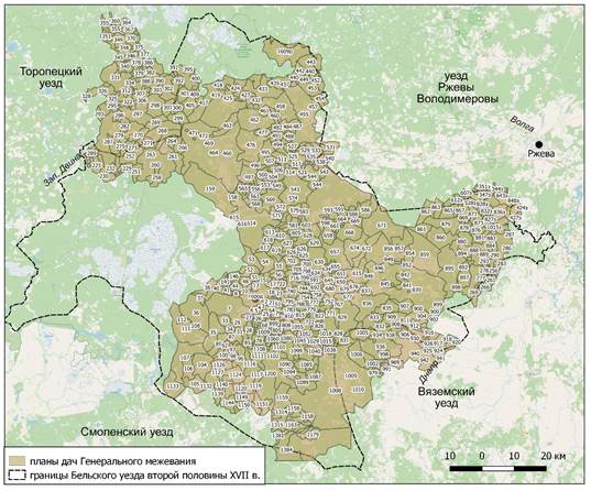
Fig. 1. Linking the plans of dachas of the General Land Survey of the Belsky district of the second half of the XVIII century in GIS. It can be stated that these cartographic materials, in comparison with similar ones for neighboring Toropetsky, Vyshnevolotsky, Tver counties, give more errors in the distances between objects. This is especially true for large dachas in watershed territories, as well as on the site along the border with Vyazma county. Nevertheless, F.F. Schubert's maps [36] and especially I.A. Strelbitsky's [35] make it possible to fill in the gaps and inaccuracies of cartography of the XVIII century. Large-scale military topographic maps of the 1940s are also informative, which have well-preserved historical toponymy, in particular, in the names of tracts [40]. These materials, which have now been digitized, have shown good preservation of the historical toponymy of the 17th century Belsky district. For most municipalities, more than 50% of toponyms are localized, including wastelands (Fig. 2). 
Fig. 2. Localization of the toponymy of the volosts of the Belsky district according to the scribe descriptions of 1657 and 1668. (in %). The names of many landowners not only in the second half of the 17th century, but also in the 16th and first half of the 17th centuries were reflected in the names of settlements, including those that currently exist (Table 1).
Table 1. Information about the landowners of the Belsky district of the XV-XVII centuries, whose names are reflected in the toponymy. | Toponym | Location | Personalities | Period | Sources of information | | Vorontsovo | Smolensk region, Dukhovshchinsky district | The Vorontsovs | The end of the XVI – beginning of the XVII century. | [16, l. 11] | | Kirkorovo | Tver region, Nelidovsky district | Ivan Kirkor, Smolensk nobleman | The second half of the XVII century. | [23, l. 145ob. – 146ob.] | | Kovel region | Tver region, Belsky district | Kazimir, Vladislav Sangushko; Hieronymus Sangushko of Kovel, Bishop of Smolensk in 1654-1657.; | The first half – the middle of the XVII century. |
[20, L. 667].; 33, p. 441] | | Monino (Monevidova sloboda) | Tver region, Nelidovsky district | Albert Monivid, village elder | The first half of the XV century. | [43, p. 51]. | | Petukhovo | Tver region, Belsky district (not preserved) | Alexey Yeremeyev, son of Rooster, Denis Rooster, Belsky gentry | The second half of the XVII century. | [23, l. 185ob., 186] | | Polnobokovo | Tver region, Belsky district (not preserved) | Polnobokovs (Polnoboks), Belsky gentry | The second half of the XVII century. | [23, l. 141ob., 176, 176ob., 177ob.] | | Pyshkovo | Tver region, Belsky district | Jan Pyshkovsky |
The first half of the XVII century. | [17, l. 562ob.; 20, l. 639ob.] | | Tatevo | Tver region, Oleninsky district | The Tatev Princes | The second half of the XVI – the beginning of the XVII century. | [16, l. 257ob.; 20, l. 266ob.] | | Temirevo | Tver region, Belsky district (not preserved) | The Temirevs | The end of the XVI – beginning of the XVII century. | [16, l. 257ob.; 20, l. 266ob.] | | Travino | Tver region, Oleninsky district (not preserved) | Danila Ivanovich Travin | The end of the XVI – beginning of the XVII century. | [18, l. 60] | | The Trambitskys | Tver region, Oleninsky district |
Trambitsky, Belsky gentry | The second half of the XVII century. | [23, l. 183ob. – 184ob.] | | Shaitrovism | Tver region, Belsky district | Martin Vasiliev, Shaitor's son, Belsky nobleman | The second half of the XVII century. | [23, l. 186-187] | The first result of the work in GIS was a detailed mapping of the land ownership of the Belsky district in the second half of the 17th century. (Fig. 3). 
Fig. 3. The location of the points of palace and manor land ownership in the territory of the Belsky district in the second half of the XVII century. Attributive tables with data from sources of this period became the basis for further retrospective study of the territorial structure of the XVI – half of the XVII century. In the course of this work, the toponymic information of the acts of the Lithuanian Metric was localized with the indication of affiliation in the attribute table, which made it possible to compare different time data and trace the dynamics of land ownership. In addition, the work in GIS allowed us to determine the size of municipalities and population indicators (the number of settlements per square kilometer and the number of wastelands) (Table 2). Table 2. The size and population of the volosts of the Belsky district in the second half of the 17th century (according to the census books of 1657, 1668 and 1675). | Municipality | Dimensions, sq. km. | Number of settlements (1657 and 1668) | Number of yards | Number of settlements per square km. | Number of yards per square km | Number of wastelands (1668, 1675) |
| Biberevskaya (Dubrovskaya) | 651,4 | 189 | 511 | 0,29 | 0,78 | 76 | | Rozhenskaya | 190,9 | 21 | 36 | 0,11 | 0,19 | 58 | | Pustozalesskaya | 800,1 | 12 | 18 | 0,01 | 0,02 |
62 | | Poniklinskaya | 484,1 | 27 | 46 | 0,06 | 0,09 | 27 | | Zhukopovskaya | 287,5 | 15 | 26 | 0,05 | 0,09 | No data available | | Zharkovskaya (Starkovskaya) | 973,9 | 141 | 275 | 0,14 |
0,28 | 52 | | Moninskaya | 646,8 | 59 | 114 | 0,09 | 0,18 | 92 | | Berezovskaya Street | 273,2 | 78 | 102 | 0,28 | 0,37 | 58 | | Shoptovskaya | 687,5 | 62 | 93 |
0,09 | 0,13 | 63 | | Verkhovskaya Street | 755,4 | 108 | 268 | 0,14 | 0,36 | 111 | | Yegoryevskaya | 247,9 | 117 | 168 | 0,47 | 0,68 | 77 | | Ponizovskaya street | 828,2 | 110 |
181 | 0,13 | 0,23 | 34 | | Ladyzhskaya | 363,2 | 75 | 122 | 0,21 | 0,34 | 120 | | Klimyatinskaya | 181,9 | 87 | 149 | 0,48 | 0,82 | 19 | | Chichatskaya | 661,1 |
60 | 69 | 0,09 | 0,10 | 24 | | Bolotovskaya Street | 446,1 | 14 | 16 | 0,03 | 0,04 | 16 | | Usacherskaya | 193,4 | 28 | 35 | 0,14 | 0,18 | No data available | | Simanovskaya |
908,2 | 9 | 13 | 0,01 | 0,01 | 28 | | Dneprovskaya | 349,7 | 12 | 21 | 0,03 | 0,06 | 180 | | Osuyskaya (Lustskaya) | 595,1 | 12 | 26 | 0,02 | 0,04 | 45 |
Sources of the second half of the 17th century record extensive palace land ownership in the Belsky district. The instructions of the I.I. Zamytsky census book indicate that a significant part of it was formed from the confiscated lands of the Alekseevsky Jesuit Collegium in Vitebsk [22, l. 1; 25, l. 1]. The establishment of the collegium's domain can be attributed to 1637, the time of the founding of the Jesuit residence in Vitebsk. The census of I.I. Zamytsky does not indicate the volost affiliation of settlements. However, it appears in the book of the tax collection of 1650 [33, p. 442] and is confirmed by comparing the description with earlier archival material and later censuses, in particular, the census of V.M. Oscherin and V. The Second World War in 1675 These are Biberevskaya (Dubrovskaya), Zharkovskaya (Starkovskaya), Moninskaya, Berezovskaya volosts. There are also lands of the Pustozalessky and Poniklinsky volosts with a churchyard, Empty Zalesye, etc. Drooped, which appear in documents as volost units only since the 1660s. The 14 villages of Zhukopovskaya volost, described by S.N. Plemyannikov, also belonged to the possession of the Jesuits. In total, this massif, which mainly covered the northern part of the county, included 266 villages (Fig. 4). 
4. Possessions of the Vitebsk Jesuit Collegium in the Belsky volosts (1637-1654). S.N. Plemyannikov's census of March 1657-1658 covered the other palace lands of the Belsky district. This description contains a rubric by municipality. The census begins with Ponizovskaya volost, continues with Klemyatinskaya, Chechatskaya, Ladyzhskaya, Yuryevskaya, Verkhovskaya, Dneprovskaya, and ends with Shoptovskaya. This fund included 180 villages, 360 households, confiscated from the gentry who remained in service in the Polish-Lithuanian Commonwealth, and the clergy. In particular, among the palace lands, the former residence of Hieronymus Sangushko Kovelsky, bishop of Smolensk in 1654-1657, "Kovelshchizna" (His name is reflected in the name of the village of Kovelshchyna that has survived to this day) is found [323, p. 441]. The same land ownership (400 portages) appears for the Sangushko family in the conservation of 1639 [20, L. 667]. In total, the palace lands of the Belsky district, according to the descriptions of 1657, included 446 villages, 630 peasant households (52 hundred and half a thousand) and 242 Bobyl. The household census form did not include information on the size of arable land, but there is a description of fishing, mills, marinas and forest lands. The most densely populated palace lands were the basins of the Obsha, Mezhi and Veles rivers. The largest in the Belsky district were the palace villages of Biberevo (29 yards), Monino (23 yards) and Zharki (17 yards). The yard capacity of 70% of settlements was 1-2 yards. The areas of Biberevskaya, Starkovskaya, and Moninskaya volosts included extensive forest and wetlands - remnants of the ancient Okovsky forest [5]. On General Land Surveying plans, they usually correspond to the largest land cottages: see, for example, cottages Nos. 464 and 159 (along the marshy section of the Mezhi River), 838, 859, 895 in the upper reaches of the Dnieper and on the watershed of the Dnieper and tributaries of the river. Osugi (Volga basin). Local forest resources have long been sources of livelihood for important industries. A number of documents from the Polish period are known for the manufacture of "forest products" - coal, potash (pyplya), saltpeter (vancha) [31, p. 16], riveting (boards, bars used for the manufacture of containers for mining) [32, p. 165] and limestone mining. For example, Mikhail Unikhovsky received the right to manufacture forest products in the vicinity of the village of Solovo in the Usachersk volost in 1639 [20, p. 659]. The Vitebsk Jesuit Collegium leased part of the forest lands ("Yes, Germans from Riga came to the same parish, they hired an oak tree from the peasants, and the oak was burned in Dorogachev") [22, l. 48]. In the second half of the 17th century, after the transfer of these lands to the palace department, the forest lands became the subject of special state attention. The potash industry is beginning to develop in Russia, particularly in the Smolensk Region, whose products were important for the domestic needs of the state and had good sales on the foreign market. In 1659, a decree was signed "On the non-removal of forests to work camps by anyone, by any decree, and on writing about it to the sovereign" [13, p. 486]. Central institutions are beginning to collect information about the quality and nature of Smolensk forests, including in the Belsky palace volosts [34]. In 1668, the Belsky voivode Bogdan Tolstoy "sent a painting to the pleasant weekday forests, which were described by the noble Semyon Ratnov upon inspection" [14, l. 1ob., 2]. Lands were identified along the Veles River and the Ushitsa River in Zharkovskaya and Bibirevskaya volosts. In 1675, the lawyer of the Sytny Palace, V.M. Oscherin, and the clerk of the Sudny Palace Order, V. The second were instructed to conduct a patrol of the palace volosts of the Belsky district and at the same time "start up" various crafts, including "building houses, and making riveting, and vanching, and dusting" [26, l. 47]. During the census, dense forests were identified in the Moninsky volost, down the river Mezha, but their condition was not the best, since "in those places where such forests are, there are a lot of sediments and sand around the hollow waters" [26, l. 438ob.]. The palace was also responsible for the areas with "red" timber, board lands and mines. However, if forestry was exclusively the subject of state economy, then the mines, which had no important economic significance due to the low quality of the iron produced in them, were given to local landowners and peasants for rent. In particular, the mine in Zharkovskaya volost on the Melcheitsa River was rented over the years by the nobles Yakim and Lukash Tyutchev [29, p. 472] and by local mining peasants for "ten rubles for a year" [26, l. 183ob., 184]. The numerous wastelands of the palace fund were given out of the rent for arable land and haymaking to the local gentry, the White townspeople and the peasants. It is difficult to estimate the size of these lands based on available sources, but the ratio of the number of wastelands to the number of settlements and the size of municipalities indirectly reflects the degree of settlement. It is obvious that the largest share of the lands lying in the desert was in the Dnieper, Pustozalesskaya, Moninskaya and Osuyskaya volosts (Table. 2), which account for large areas of woodlands (Fig. 5).

5. The ratio of settlements and wastelands in the volosts of the Belsky district according to the censuses of 1657 and 1668. Thus, the palace land ownership in the Belsky district of the second half of the 17th century was formed from lands confiscated from the owners of the Polish period and included both well-developed territories and extensive forest areas, which served as an important strategic resource. In the second half of the 17th century, local land ownership was located in almost the entire territory of the county, with the exception of Dneprovskaya and Zhukopovskaya volosts. The census of D. and V. Cherntsov in 1668 allows us to compare the size of the palace possessions with the local fund of the Belsky district. In total, at least 120 individual landholdings were recorded in the census book of 1668, which included 652 settlements and 1,334 households. Most of them belonged to the Belsky and Smolensk gentry. The lands of the Rachinsky, Boreish, Tronkovsky, Voivodsky, Lykoshin, and Bowyer gentry families stand out for their size. 34 possessions in the vacant lands of Lustskaya and Ladyzhskaya volosts were allocated to the Belsky Cossacks (47 people in total). They included 1 village, 31 villages, 12 Cossack, 21 peasant and Bobylsky yards. The suburban territory was occupied by lands allocated to the Belsky gunners "amicably" by the posadsky people; three of the gunners owned "their old lots, which they owned under the Polsky king" [23, l. 246ob.]. The size of the Pushkar land is indicated in the census in portages and morgues (3 portages with a half-cart and 14 morgues) [23, L. 247]. The most densely populated local lands were the basins of the Obsha, Bereza and Luchesa rivers, as well as suburban territories south of Belaya, in Ladyzhskaya, Klemyatinskaya and Chichatskaya volosts. The indicators of the courtyard are about the same as on the palace grounds.: 73% of settlements consisted of 1-2 yards. The largest owner villages were Verkhovye (12 yards) and Primoshye (10 yards). The combination of spatial data shows that a very small proportion of the palace possessions in the period from 1657 to 1675 were affected by land distributions. These are observed in Verkhovskaya, Poniklinskaya, Klimyatinskaya, Ladyzhskaya, Chichatskaya volosts; these lands were transferred to representatives of the Belsky and Smolensk gentry, who swore allegiance to Tsar Alexei Mikhailovich. Dneprovskaya and Zhukopovskaya volosts remained completely untouched by land distributions until the mid-1670s. On the contrary, there was no palace land ownership in the Simanovsky volost, which was assigned from the Vyazma district after the demarcation of the Russian-Polish border after the conclusion of the Polyanovsky Peace [38]. Based on the data from the 1668 census and earlier sources, it can be argued that the majority of representatives of the local gentry confirmed their former possessions in the orders of the Principality of Smolensk and the Grand Duchy of Lithuania based on the privileges of the Polish period. Landowners have repeatedly justified their right to land by owning "under the king" and the relevant documents, as evidenced by the repeated instructions of the 1668 census. The data recorded by the 1668 census is linked to information from the acts of the 1620s and 1630s. Continuity is noted in both geographical and personal characteristics of landholdings, including the Moscow period of the second half of the XVI – early XVII centuries. The information that has been identified is given in Table 4. Table 4. Land holdings of Belsky uyezd in the second half of the XVI – second half of the XVII century. according to the acts of the 1610s – 1630s and the census book of 1668 (succession). | Municipalities | Points (names are given according to data from the 1610s and 1630s) | Landowners of the second half of the XVI – early XVII century. | Landowners of the first half of the XVII century. | Landowners of the second half of the 17th century. | Sources | | Chichatskaya | Pyzhovo, Minino, Muravyovo, Mikhalek |
Prince Fyodor Andreevich Yeletsky | Domushy Fedorovich Samson, Krystof Poplonsky | Ilya Voevodsky | [18, l. 54, 74ob., 128, 128ob.; 23, l. 216ob. – 219] | | Chichatskaya, Osuiskaya | Medvedevo, Lychevo, Lukino, Lapkino, Volynovo, Demikhovo | Andrey (Semenovich?) Kolychev | Jan, Josef, Pavel Novitsky | Gregory of Penza | [4, p. 345; 15, l. 308, 308ob.; 16, l. 286; 20, l. 163, 163ob., 714-715ob.; 23, 213, 213ob.] | | Chichatskaya, Berezovskaya | Spiridovo, Telishchevo, Klapikovo, Burov, Ryzhev | Peter Volynsky | Bartosz Kosecki, Jan Nowicki | Ilya Voevodsky | [15, l. 250ob.; 20, l. 373; 23, l. 214ob. – 216] | | Pyshkovskaya | Pyshkovo with dd. |
Prince Andrey Romanovich of Tyumen | Mikolai Korvin Gosevsky | Vladimir Kurosh | [15, l. 372ob., 373; 30, p. 20] | | Pyshkovskaya | Kohanovo, Drablovo, Timokhovo, Mishnevo, Karpovo, Kharlanovo, etc. | Putila Fyodorovich Rezanov | Jan Pyshkovsky | Stepan Karbutovskydenis Schweikovsky | [17, l. 562ob.; 20, l. 639ob.; 23, l. 114, 123ob, 124] | | Berezovskaya, Usacherskaya | Tatevo | Prince Semyon Andreevich Tatev | Jan, Maciej, Vladislav Bernatsky | Bogdan Tolstoy | [15, l. 257ob.; 20, l. 266ob.; 23, l. 148ob. – 151; 33, p. 457] | | Verkhovskaya Street | Berladovo, Podvano, Orlovo, Nesterovo, Tonino, Vorotkovo, Iskrino, Padaltsovo, Staroselye, etc. | Vasily Rzhevsky |
Bernat Krushensky | Akinfiy Buturlin | [15, l. 269ob.; 125ob. – 127ob.] | | Shoptovskaya | Khlomova, Bolotovo, Zudnya, Korenevo, Savkino | Grigory Alekseev Avinitsky | Grigory Milashevich | Gavril Lukashev | [15, l. 277, 299, 414ob.; 18, l. 28ob.; 23, l. 156-156ob.] | | Usacherskaya, Chichatskaya | Artemovskoe | Dmitry, Yuri Telichin (Telitsyn) | Mikolai Korvin Gosevsky | Ivan Poplonsky | [4, p. 3585; 14, l. 385; 23, l. 227ob. – 230] | | Ponizovskaya street | Temirevo, Shershnevo | The Temirevs | Philip Bucholt, Samuel Drutsky-Sokolinsky, then Dmitry, Pavel, Elizar Boreisha | Ortemy Boreisha |
[20, l. 373ob., 604ob.; 23, l. 68ob. – 69ob.; 33, p. 457] | | Shoptovskaya | Travino (Parkhomovo) | Danilo Ivanovich Travin | Jan Sklotovsky | Konstantin Sklotovsky | [33, p. 490; 23, l. 160] | | Yegoryevskaya | Morozovo | | Jan, Danilo Rachinsky | Widow Anna Ivanovskaya Rachinsky's wife | [21, l. 222; 23, l. 92; 33, p. 487] | | Ladyzhskaya | Zlobino | | Denis Rooster | Alexey Yeremeyev son of a Rooster | [33, p. 483; 23, l. 185ob.] | |
Ladyzhskaya | Maximovo | | Stanislav Burnevsky | Peter Burnevsky | [33, p. 458; 23, l. 180] | | Shoptovskaya | Fedorova | | Martin Tronkowski | Tronkovsky | [33, p. 495; 23, l. 164] | | Ladyzhskaya | Voshnevo, Zavorovo | | Jerzy Kulesz | Yakov Kulesh | [20, l. 465ob.; 23, l. 189, 189ob.] |
These data reflect the continuity of the gentry's possessions in the first and second half of the 17th century. For example, the lands in the Ponizovskaya volost, to which Dmitry and Pavel Boreisha received privileges in the 1630s [20, l. 373, 604], were retained in the 1660s by Artemy Boreisha, who confirmed his privilege in the order of the Grand Duchy of Lithuania in 1662 [23, l. 68]. – 69ob.]. The ownership of Jan Rachinsky in the Yegoryevskaya volost [21, l. 222] was retained by his widow and children [23, l. 88ob. – 95], Jerzy Kulesh in the same volost [20, l. 465] – by Yakov Kulesh [23, l. 95-96, 98]. The names of the Burnevskys, Tronkovskys, Sklotovskys, and Cocks appear in the book of the tax collection of 1650, which are also found in the census of 1668. The boundaries of these successive possessions may well reflect the boundaries of the dachas, fixed by the General Land Survey (Fig. 6). 
6. Succession of landholdings in the second half of the XVI – XVII centuries. (alignment within the boundaries of the dachas of the General Land Survey). A – possessions of the Temirevs (late XVI – early XVII century), D., P. Boreisha (first half of the XVII century), A. Boreisha (second half of the XVII century); B – possessions of the Rachinskys (XV II century); C – possessions of the Tatevs (second half of the XVI – early XVII century), I., M. Bernatsky (the first half of the 17th century), B. Tolstoy (the second half of the 17th century); Mr. Travin (the end of the XVI – beginning of the XVII century.), J. Sklotovsky (the first half of the XVII century.), K. Sklotovsky (the second half of the XVII century.). The localization of land holdings clearly reflects the relationship of ownership history with the formation of the administrative structure of the county. In particular, in the 1620s, there was already the possession of Jan and Krystof Poplonsky (Poplavsky) [15, l. 385b.], which was formed on the basis of the former lands of Prince Fyodor Andreevich Yeletsky, Dmitry and Yuri Telichin (Telitsyn) – landowners of the previous Moscow period. In 1640, Jan Poplonsky supplemented this possession with the village of Solovo, purchased from Mikhail Unikhovsky [23, l. 230]. As a result, by the 1660s, the Usacherskaya and Bolotovskaya volosts were formed, the territories of which were almost completely occupied by Ivan and Leonty Poplonsky, including Lake Usacher (Vysochert), which was their "former" possession [23, l. 224-233] (Fig. 7). 
7. Possessions of Ivan and Leonty Poplonsky (the second half of the 17th century), forming the Usacherskaya and Bolotovskaya volosts. Gavrilovskaya volost is mentioned in Polish documents in connection with villages located along the Gavrilovka River, south of Belaya [15, l. 250ob.; 20, l. 373]. Later, this small area was included in the descriptions of the Chichatsky parish. The combination of spatial data from different sources in GIS makes it possible to trace the continuity in the location of land holdings in Moscow at the end of the XVI – beginning of the XVII century, the period of the Polish-Lithuanian Commonwealth (1620-1640s) and the second half of the XVII century (Table 4). The Poplonsky estates, formed on the basis of the possessions of Princes F.A. Yeletsky and the Telichins, have already been mentioned above. The Tatev princes' land ownership on the Bereza River was probably formed in the second half of the 16th century. A descendant of voivode Peter Tatev [11], Semyon Andreevich Tatev appears as a former landowner. Tatevo and eight villages in Berezovskaya volost in 1620 Jan and Maciej Bernacki [16, l. 257]. They also appear as the owners of Tatevshchizna in the book of the tax collection of 1650 [33, p. 457]. Probably, after the confiscation, the possession passed to the palace department, and then to the Belsky voivode Bogdan Tolstoy [23, ll. 148b. – 151]. The possessions of the Boreisha family in the Ponizovskaya volost probably date back to the boyars of the Temirev ("Temirovshchizny"), a well–known family of serving Tatars. Relatively few examples of changes in the boundaries of possessions as a result of fragmentation or merger of ownership structures have been identified. In particular, it is observed on the lands of Pyshkovsky volost, which was recorded in documents of the 1610s-1630s. The former lands of Princes Vasily Tyumensky and Ivan Khovansky in the Polish period passed to several landowners, including Jan Pashkovsky (Pyshkovsky) [17, ll. 562ob.]. It can be assumed that the mentions of this volost, its names and S. Pyshkovo itself is associated with this genus in the documents of the Polish period. In the second half of the 17th century, new landowners were registered here. Pyshkovsky volost no longer appears in the sources of this time; its territory merges with Verkhovskaya Volost (Fig. 8). 
8. Pyshkovsky volost of the first half of the 17th century. (combination in GIS within the boundaries of the dachas of the General Land Survey). The villages of the boyars Andrei Kolychev and Peter Volynsky, owners of the turn of the XVI–XVII centuries, who passed over to Ya during the Polish period, are recorded in the Chichatsky volost. Nevelsky and Ya. Novitsky [15, ll. 250ob., 308, 308ob.; 20, ll. 163, 163ob., 714-715ob.], and after the final transition of Belaya to the Russian state – the Belsky gentry of the city of Penza [23, ll. 213, 231ob.] and AND . Voivodsky [23, l. 214-219]. A small landholding in the south of the county, assigned in 1625 to the Church of John the Theologian in Belaya (Nefedovo, Shevnino, Sitovka, Losmino) [44, p. 193-194], became part of a large estate in the second half of the 17th century. Voivodsky district.
Thus, the processing of a large volume of historical and geographical information in GIS made it possible to characterize the location and dynamics of land ownership in the territory of the Belsky volosts. Formed from confiscated lands, the palace land ownership in the Belsky district in the 1650s - 1670s was only slightly inferior in size to the nobility and Cossacks, which largely remained with the former owners. Despite the obvious variability of the volost composition, related both to the formation of land ownership and the process of rural settlement, as well as to the change in the political status of the region, nevertheless, the continuity of the geographical characteristics of a number of land holdings remained. This can be traced between the estates of the Russian nobility of the second half of the XVI – early XVII century. and the estates of the gentry in both the first and second half of the XVII century. The cartographic materials of the General Survey of the 18th century digitized in GIS in this case serve as a visual reflection of the limits of these territorial structures that existed for a long time. Taking into account the fact of continuity in the geography of land ownership, it can be assumed that for at least the XVI–XVII centuries, the parameters of the development of the territory in the Belsky volosts were preserved. Probably, the presence of extensive forests and wetlands contributed to this. Based on the reconstruction obtained in GIS, it can be concluded that with the total area of the county of about 11 thousand square kilometers, about 5 thousand square kilometers accounted for the uninhabited spaces that led to the existence of forestry here. In general, it is possible to state low rates of settlement of the territory of the county even in the second half of the XVII century. for all types of land ownership.
References
1. Acts of the Moscow State published by the Imperial Academy of Sciences (Ed. N.A. Popov). (1890). Volume 1: Razryadny Prikaz. Moscow Table. XLIV, 766 pages.
2. Acts relating to civil proceedings of Ancient Russia (Collected and published by A. Fedotov-Chekhovsky). (1860). Volume 1, 500 pages.
3. Acts relating to the history of Western Russia, collected and published by the Archeographic Commission. (1848). Volume 2: 1506-1544, 437 pages.
4. Acts relating to the history of Western Russia, collected and published by the Archeographic Commission. (1851). Volume 4: 1588-1632, 583 pages.
5. Alekseev, L.V. (1974). Okovsky forest in the Tale of Bygone Years. In Culture of Medieval Russia (pp. 5-11).
6. Boyar lists from the last quarter of the 16th – early 17th centuries and the roster of the Russian army of 1604 (Compiled by S.P. Mordvinova and A.L. Stanislavsky). (1979). 341 pages.
7. Web-GIS "Belsky District in the 17th Century." NEXTGIS [Electronic resource]. Retrieved from https://belaya.nextgis.com/resource/1/display?panel=layers
8. Vodarsky, Y.E. (1977). Population of Russia in the late 17th – early 18th centuries (size, estate-class composition, distribution).
9. Tenants of Novikov, compiled in 1596. (1909). Izvestia of the Russian Genealogical Society, 3, 143-144.
10. Catalog of scribal descriptions of the Russian state from the mid-15th to the early 17th century (Compiled by K.V. Baranov). (2015). 124 pages.
11. The Livonian campaign of Tsar Ivan Vasilyevich the Terrible in 1577 and 1578. (1853). Military Journal, 5, 95-110.
12. Inventory of the Archive of the Embassy Prikaz from 1626 (Ed. S.O. Schmidt). (1977). Part 1, 416 pages.
13. Complete collection of laws of the Russian Empire. (1830). Volume 1 (1649-1675), 1072 pages.
14. RGADA. Fund 145. Inventory 1. Case 8.
15. RGADA. Fund 389. Inventory 1. Book 96.
16. RGADA. Fund 389. Inventory 1. Book 97.
17. RGADA. Fund 389. Inventory 1. Book 99.
18. RGADA. Fund 389. Inventory 1. Book 101.
19. RGADA. Fund 389. Inventory 1. Book 102.
20. RGADA. Fund 389. Inventory 1. Book 108.
21. RGADA. Fund 389. Inventory 1. Book 110.
22. RGADA. Fund 1209. Inventory 1, part 1. Case 596.
23. RGADA. Fund 1209. Inventory 1, part 1. Case 597.
24. RGADA. Fund 1209. Inventory 1, part 1. Case 857.
25. RGADA. Fund 1209. Inventory 1, part 2. Case 15162.
26. RGADA. Fund 1209. Inventory 1, part 2. Case 15164/14.
27. RGADA. Fund 1354. Inventory 446. Part 1 (Alphabet No. 197).
28. RGADA. Fund 1356. Inventory 1. Cases 5326-5334.
29. Russo-Belarusian relations: Collection of documents. (1570-1667) (Ed. L.S. Abetsedarsky and M.Y. Volkov). (1963). 534 pages.
30. Collection of the Imperial Russian Historical Society. (1882). Volume 35: Monuments of diplomatic relations of Ancient Russia with foreign powers, 870 pages.
31. Dictionary of the Russian language of the 11th – 17th centuries (Compiled by G.A. Bogatova and G.Y. Romanova). (1975). Volume 2, 319 pages.
32. Dictionary of the Russian language of the 11th – 17th centuries (Compiled by V.Y. Deryagin, O.I. Smirnova, and G.P. Smolitskaya). (1980). Volume 7, 403 pages.
33. Smolenshchina in the documents of the Lithuanian metric of the first half of the 17th century: owners and their estates (Author-compiler V.A. Prokhorov). (2017). 543 pages.
34. Speransky, A. (1935). Potash factories in Smolensky district in the 17th century. Red Archive, 4(71), 117-121.
35. Special map of European Russia 1865-1871 [Electronic resource]. Retrieved from http://www.etomesto.ru/map-karta-strelbickogo/.
36. Special map of the Western part of the Russian Empire, compiled and engraved in 1/420000 scale during the military-topographic depot, under the management of General Quartermaster Neidhardt, led by Lieutenant General Schubert, 1832. Leaves XXIII, XXIV, XXIX, XXX [Electronic resource]. Retrieved from http://www.etomesto.ru/map-shubert-10-verst/
37. Stepanova, I. (2023). Volosts of Belaya in 16th-17th centuries: historical-geographical characteristic of the region on the Western border of The Russian State. Genesis: Historical research, 10, 32-40. https://doi.org/10.25136/2409-868X.2023.10.68730
38. Stepanova, Y.V. (2024). Delimitation of the Russian-Polish border in 1634-1637: "as the ancient old settlers led." ENOJ "History," 15(7), 141. Retrieved from https://history.jes.su/s207987840032011-1-1/.
39. Temushev, V.N. (2013). The First Moscow-Lithuanian Border War: 1486-1494.
40. Topographic military map of the Workers-Peasant Red Army, 1941. [Electronic resource]. Retrieved from http://www.etomesto.ru/map-rkka_n-36-b/
41. Florya, B.N. (2001). Information on land ownership of Russian nobility at the end of the 16th – beginning of the 17th century in the documents of the Lithuanian metric. Russian Diplomatarium, 7, 403-414.
42. Frenchova, E.K. (1983). Map of the administrative-territorial division of Smolenshchina in the second half of the 17th century. In Problems of Historical Geography of Russia. Volume III: Issues of Historical Cartography (pp. 73-87).
43. Ochmański, J. (2003). Moniwid and his family. Lituano-Slavica Posnaniensia, 9, 3-73.
44. Rogatschewski, A. (2015). On the history of Magdeburg law and urban self-government in Russia. The city of Belyj (17th-18th centuries). In From Saxony-Anhalt to the World. The Sachsenspiegel as a European legal source (pp. 123-210). Peter Junkermann Verlag.
Peer Review
Peer reviewers' evaluations remain confidential and are not disclosed to the public. Only external reviews, authorized for publication by the article's author(s), are made public. Typically, these final reviews are conducted after the manuscript's revision. Adhering to our double-blind review policy, the reviewer's identity is kept confidential.
The list of publisher reviewers can be found here.
The reviewed article is devoted to the study of the geography of land ownership in the Belsky district in the XVI—XVII centuries, using the methods of geographic information systems (GIS) to reconstruct the spatial distribution of land and analyze changes in the structure of land ownership. The study covers numerous aspects related to the history of the region, including the impact of political events, economic activity, and the social structure of the population. The main methodological basis of the article is the use of GIS technologies for processing and visualizing data from census books and other historical sources. The authors conducted a thorough analysis of archival materials such as scribal books, deeds and other documents related to land ownership. The use of spatial analysis methods made it possible to reconstruct the historical map of the county and identify key trends in the distribution of land between different social groups. The study is relevant due to the lack of study of the topic of Belsky land ownership in the XVI-XVII centuries, especially in the context of its historical position on the Russian-Lithuanian border. Studying this topic helps to better understand the processes of formation and development of regional communities, as well as the role of political decisions in shaping the social structure. The work makes a significant contribution to scientific knowledge through the use of modern technologies to analyze historical data collected in the Russian State Archive of Ancient Acts. For the first time, such a large-scale reconstruction of the spatial structure of land ownership in the Belsky district has been carried out, opening up new opportunities for further research in the field of historical geography and regional history. The cartograms presented in the article play an important role in data visualization and analysis of the spatial distribution of lands, provide a visual representation of the location of various types of landholdings, such as palace and manor lands, as well as the density of settlement of territories. One of the key advantages of cartograms is their ability to show the dynamics of changes in land ownership over the period under review, and to better understand the interaction between various factors such as land policy, economic activity, and demographic processes. The use of GIS technologies to create cartograms makes it possible to use quantitative analysis methods, which significantly increases the accuracy and objectivity of conclusions. It should also be noted that cartograms facilitate the integration of various sources of information, such as scribal books, acts and other historical documents, which allows for a holistic view of the geography of land ownership. The article has a clear structure, divided into logical blocks, each of which is devoted to individual aspects of research. The bibliographic list includes a wide range of historical sources and modern research. The authors offer convincing arguments in favor of their position, supporting them with rich factual material. The article offers a unique approach to the analysis of historical data through the prism of modern technologies, with the help of spatial structure reconstruction, it provides an opportunity to see the dynamics of medieval land ownership in a unique format. The observations are given in a broad historical context, which allowed us to consider socio-economic processes in close connection with the political situation. The main conclusion about the predominance of palace lands over landlords seems to be justified. The article will be of interest to a wide range of readers interested in the history of Russia, especially specialists in the field of historical geography, agrarian and regional history. Despite minor shortcomings, the article "Geography of land ownership in the Belsky district in the XVI-XVII centuries: reconstruction in GIS" deserves publication in the journal Historical Informatics, as it offers a new look at a little-studied topic and uses modern data analysis methods.
|


